
When looking back on the year, there are bouts of extreme weather that stand out in our minds. For almost every part of Canada, 2021 was one of those years — to say the least.

2021 was bookended by windstorms in the west and folks across the country saw plenty of flooding, smoke, drought, and wildfires in between.
“Not in 26 years… has there been anything comparable to this year, where Canadians endured such a stream of weather extremes,” Environment Canada wrote in their summary of the year’s weather.
“There was no new types of weather this year – our grandparents coped with the same rain, heat, floods, fires and drought. But the extremes were of a different nature than in the past. They were more widespread, intense, frequent and impactful.”
We asked Global News’ Chief Meteorologist Anthony Farnell to tell us what made these weather events so unique, or what really stood out while he was analyzing them.
Severe storm, tornado damage areas south of Calgary
High winds and hail pummelled regions south and east of Calgary, from High River to Brooks, in early June, leaving trees toppled, branches strewn, and at least one person pinned beneath a fallen tree.

A tornado touched down near the town of High River for about 10 minutes that weekend. Luckily, no one was hurt.

Read more: From a mother’s plea to get vaccinated to catastrophic floods, here are our top videos of 2021
Heat dome smashes records in B.C. and Alberta
In late June, temperatures in Western Canada skyrocketed under a heat dome, sending temperatures to torrid heights, and making it the hottest week in Canadian history.
Heat warnings were posted across B.C. and Alberta, large parts of Saskatchewan, Northwest Territories, and a section of Yukon. A total of seven Canadian locations broke the previous national heat record that had been recorded in 1937.

For almost two weeks, daytime highs sat 15 to 25 degrees above normal, and with it came crippling drought, the effects of which farmers are still feeling to this day.
The heat dome lasted from June 24 to July 4, growing in size every day. Soon, parts of Eastern Canada were also experiencing weather associated with the heat dome.

In total, the heat dome broke 1,000 daily Canadian temperature records, and more than 100 records registered between 40 and 50 C. More than 500 people and 650,000 animals perished as a result of the heat.
Farnell’s Take: The heat dome over B.C. and Alberta for the second half of June was incredible on so many levels. Drought conditions already existed across the region, which was only made worse when the heat dome arrived. Temperatures soared to levels never seen before in Canada and this was made worse because of the dry ground and also the effects of climate change.
Lytton, B.C. stood out in particular as a poster city for climate change, with the all-time Canadian record high temperature being broken on three consecutive days — followed by the devastating wildfires burning most of the city to the ground. The temperature record of 49.6 C set in Lytton will likely stand for quite some time.
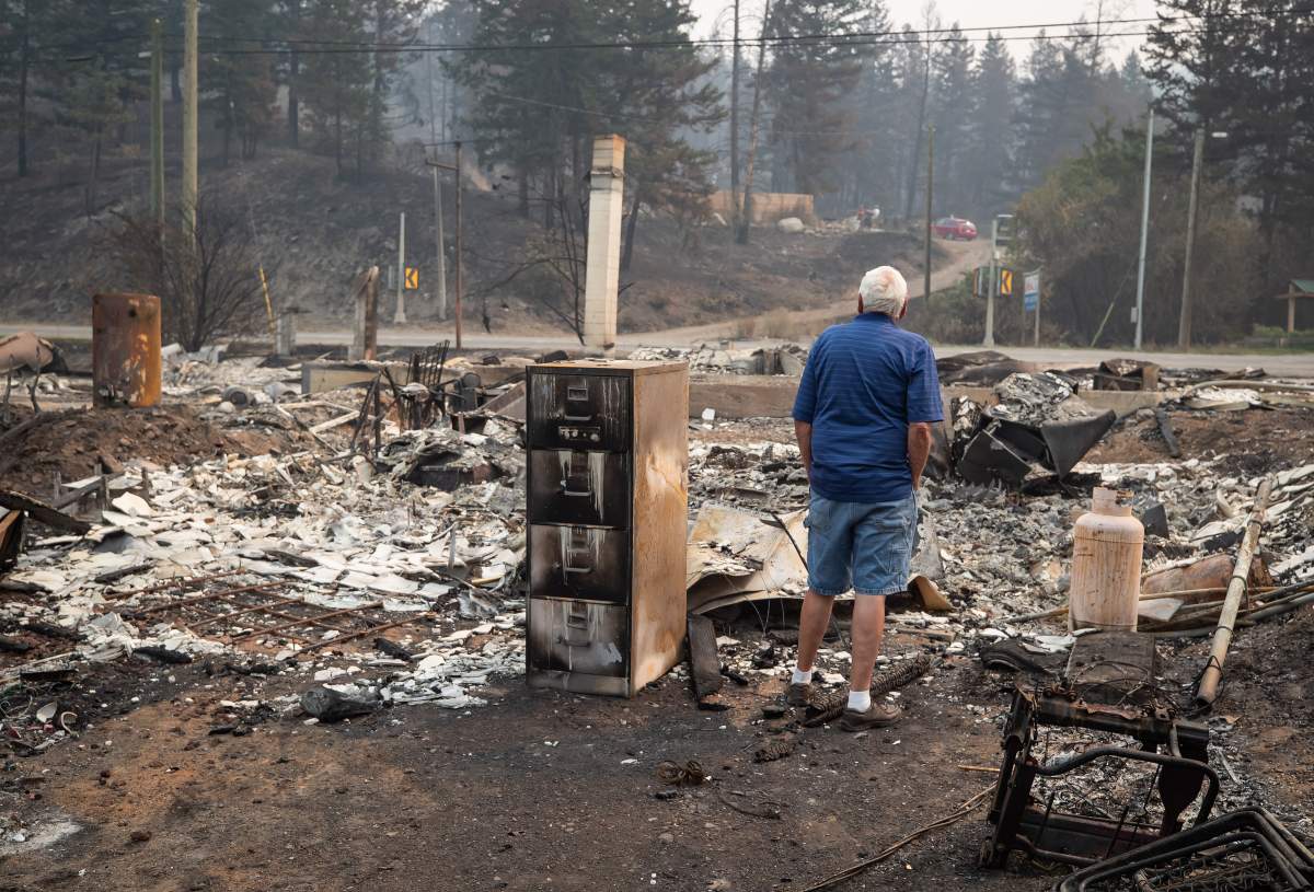
The B.C. wildfires

Get breaking National news
British Columbia’s 2021 wildfire season saw the destruction of the village of Lytton and homes levelled in several other Interior regions, but the B.C. Wildfire Service says it was not the worst season on record.
Drought-like conditions over Southern B.C., caused by the aforementioned heat dome and coupled with severe lightning storms, helped spark as many as 40 new fires every day in July.
At the height of the fires, the daily number of active blazes was over 300, triggering 181 evacuation orders and 304 evacuation alerts. A provincial state of emergency was declared on July 21 and wasn’t lifted until Sept. 14.
There were 67 wildfires of note across B.C., involving response efforts from nearly 4,000 people during the intense season, including crews from Mexico, Australia and across Canada.

Farnell’s Take: Watching the heat records being set out west and knowing how dry the ground was had most meteorologists very concerned for wildfires. The heat dome had to break down at some point and when it did, it came with wind and lightning, which sparked numerous fires.
It’s important to note that the fire season in B.C. was nowhere near a record but all eyes were on the province after the record heat and likely heat-related deaths. Much like the heat records, Lytton made international headlines for all the wrong reasons when the city caught fire in an instant.
Wildfire smoke chokes out a huge swath of Canada
As B.C. scrambled to deal with raging wildfires, Alberta and Interior B.C. became increasingly choked by wildfire smoke over the summer. Very high air quality health index values were reported day after day for weeks on end, only seeing a brief reprieve from the occasional rain shower or shifting wind.

The smoke was so thick and heavy that it travelled over Saskatchewan and Manitoba, and even affected parts of Ontario, Quebec, and the Maritime provinces. The size and reach of the wildfires was so substantial that the smoke could be seen in satellite images from space.
Many Canadians were compelled to spend more time than they would like indoors, as experts warned of the physical and mental health dangers of wildfire smoke.

Farnell’s Take: Predicting the weather is hard enough, but an increasingly important part of our job in the summer is trying to predict where smoke is headed and how thick it will be. Air quality can be greatly affected, as it was at times this summer from Alberta to Atlantic Canada. All this was from persistent wildfires burning across the northern Prairies into northwest Ontario. This smoke can get trapped in valleys or get lofted high into the atmosphere and travel with the jet stream, blocking out the sun hundreds of kilometres away.
Devastating floods caused by extreme rainfall in B.C.
2021 was the year we became familiar with the term “weather whiplash,” as our eyes turned once again to B.C.
- Edmonton’s stormwater system strained after repeated heavy rain
- First Nations chiefs call for inquiry into Ontario wildfire response
- How the Northern Tornadoes Project helps verify twisters as Alberta on track for record year
- Inquiry hears avalanche danger moderate on day of 2021 fatal Banff snow slide


In September, the province’s unusually dry and hot summer came to an end, as wildfire and drought turned to rain and wind. It all came to a head on Nov. 13, when torrential rainfall hit the province in the form of seven atmospheric rivers and three weather bombs. These storms also brought with them unseasonably high temperatures, triggering snow melt at higher elevations, contributing even further to the widespread flooding.

Rainfall totals in some areas measured 300 millimetres over two-and-a-half days. The result was historic flooding, causing highway washouts, major landslides, and power outages. Six people and 1.3 million animals died and more than 15,000 had to evacuate their homes.
Sections of the Trans-Canada Highway became impassable, and the Coquihalla Highway — a major transportation corridor — is still in the process of repair after major sections were washed away in the storms. The largest port in Canada was closed in Vancouver, and the effects are still being felt in the supply chain across Canada.

Farnell’s Take: From record heat and drought to record rain and floods, it was an incredible year of weather for B.C. residents, going from one extreme to the other. The pattern turned wet in fall but nobody suspected the force of the atmospheric rivers that would impact the southern part of the province in November.
Moisture channels called “atmospheric rivers” can transport water vapour thousands of kilometres from the tropics to the northern reaches of the planet. When these “rivers” intersect with the mountainous terrain of B.C., tremendous amounts of rain can occur. The phenomenon is nothing new, but the frequency and force of the storms this fall combined to create one of the province’s worst flood disasters.
Flooding in Nova Scotia and Newfoundland
The end of November and early December marked some of Eastern Canada’s most intense weather of the year, as high winds and heavy rains caused plenty of flooding and damage in Nova Scotia and Newfoundland.
Several atmospheric rivers and tropical storms slammed the area, leaving thousands of Atlantic Canadians grappling with disaster and causing millions of dollars in damage.
Antigonish, N.S., experienced flash flooding and washed out roads and bridges when a major storm dumped more than 200 millimetres of rain on the town on Nov. 23. That same storm dumped almost an entire month’s-worth of rain on parts of Newfoundland over one day, leaving some residents stranded by washed out and impassable highways.
Farnell’s Take: An “atmospheric river” is partly to blame for the extensive flooding across eastern Nova Scotia and Newfoundland. Almost two months of rain fell in just a couple days from a moisture stream that originated in the Caribbean and travelled hundreds of kilometres along the warm Gulf Stream.
There is increasing evidence that climate change is making these flood events worse for a couple reasons: A warmer planet (especially warmer oceans) leads to more water vapour available for these storms to feed on, plus increased blocking patterns lock in extreme weather for a longer period of time.
Windstorm in Quebec and Ontario
Hundreds of thousands of people were left without power in mid-December when a violent storm blew through parts of Ontario and Quebec, downing power poles and damaging transformers.

Winds that surpassed 100 km/h also felled trees, pulled apart fences and caused scaffolding to collapse.
Farnell’s Take: A rapidly deepening cyclone travelling across the western Great Lakes is often a big wind producer for southern Ontario and Quebec. These are more common in November, but this year the bigger fall storms waited for December.
The warm sector of the system delivered record high temperatures that reached the upper teens in places like Toronto. It was followed by winds gusting as high as 130 km/h along the shores of Lake Erie and Lake Ontario.
Comments
Want to discuss? Please read our Commenting Policy first.