


British Columbia’s summer wildfire season is shaping up to be highly regionalized, emergency officials said Monday.

In a briefing outlining the province’s current drought and fire conditions, officials with the BC Wildfire Service and B.C. River Forecast Centre outlined that drought conditions had eased over recent years in many parts of B.C.
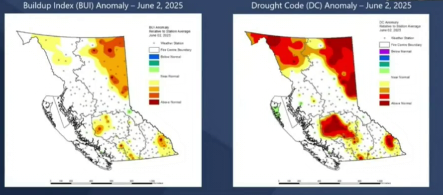
But while those regions saw “near-normal” levels of spring rain, the province’s southwest Interior, Chilcotin, far northwest and northeast continue to grapple with multi-year drought and elevated fire risks.

“Those regions may experience fire seasons comparable to the last two years,” B.C. Wildfire Service Supt. of Predictive Services Neil McLoughlin said.
“For members of the public and people that work in the northeast corner of the province, 2025 will likely feel like a fire season from 2023 or 2024, it is going to be a very busy year again — but for other regions of the province, it will be much slower.”
The BC Wildfire Service is already battling dozens of fires in the province’s northeast, including three so-called “wildfires of note” that pose an elevated risk.

Get daily National news
Local authorities have issued 10 evacuation orders related to fires in the region, affecting about 120 households.
“The summit lake wildfire, which is 100 kilometres west of Fort Nelson, is burning on both sides of Highway 97 and there are expected closures of the highway until Monday evening. The Pocket Knife Creek wildfire, which is 150 km roughly south of Fort Nelson, has also impacted Highway 97, and Highway 97 closures will continue as a result of wildfire growth,” Forests Minister Ravi Parmar said.
“The Kiskatinaw wildfire, which is 65 Kilometres south of Dawson Creek, has grown in size and has crossed the border into Alberta, resulting in the closure of Highway 52.”
As of Monday, the wildfire danger rating has been elevated to “moderate” across virtually all of British Columbia, with sizable pockets of the province listed as “extreme” risk.
David Campbell, head of the B.C. River Forecast Centre, said the risks will be exacerbated in the weeks to come by lower-than-average snowpack, which is well on its way to melting.

The amount of snow remaining on B.C. mountains currently sits at 44 per cent of normal for June, with melt accelerating in recent weeks due to hot weather.
- Cold front could escalate B.C. wildfires ahead of August long weekend
- Wildfire crisis eases in western Europe but worsens in Greece as winds drive blazes
- Improper battery disposal blamed for fire at Nova Scotia waste and recycling facility
- Loon Lake area evacuation order extends to nearly 1,500 properties due to Pear Lake fire


“We are probably a couple weeks early in terms of that melt … about two-thirds of the snow we started with this year have already melted, in a normal year, we would have probably melted about half of that,” he said.
“We are seeing the setup this year for increased drought hazard as we go through the summer months.”
Campbell said the province’s northeast was already hitting elevated Level 3 and Level 4 drought conditions. Some other parts of the province, including the Chilcotin, Vancouver Island and Southwest, are starting to see Level 1 and Level 2 drought conditions, he said.
All eyes are now on June weather, which is set to play a critical role in how severe the fire season can be.

The good news is that after a week of blistering heat, many parts of the province are forecast to see a low-pressure system bringing rain.
“June rain can really set the tone for the remainder of the fire season, so for areas that may experience a healthy amount of precipitation in the week to come here, that just really helps recover fuel moisture and lessen the fire danger,” McLoughlin said.
However, he noted that the areas already facing an elevated risk of wildfires aren’t likely to get the relief they need.
What’s more, long-range forecasting is projecting both warmer-than-normal temperatures for June and through the remainder of the summer.
That has B.C.’s Ministry of Emergency Management and Climate Readiness during people to take steps now to prepare for the effects of a potential wildfire in their community.
Those include ensuring your home has a grab-and-go bag packed and ready, pre-registering for Emergency Support Services and making sure their insurance is up to date.
Comments
Want to discuss? Please read our Commenting Policy first.