


Thirty-eight homes and 83 people in southern Manitoba were evacuated Wednesday night as a ‘one-in-1,000-year-event’ flooded the Rivers Dam and other areas in Southern Manitoba.

The evacuations came as the town of Minnedosa and the surrounding RM of Minto-Odanah declared states of emergency Wednesday afternoon.
The communities are dealing with washed-out roads, flooded home basements and businesses that have been forced to close after record-breaking rain earlier this week.
“The government no longer has confidence in the structure in the dam at Rivers, Manitoba,” said Infrastructure minister Ron Schuler at a hastily-called press conference Wednesday evening.
“Out of an abundance of caution, residents and livestock downstream of the dam, should be evacuated.”

The water flows from Lake Wahtopanah and the Little Saskatchewan River at the dam are currently more than 12,000 cubic feet per second, which exceeds 2011 flood levels, said Schuler.
“The water level at the Rivers Dam is at it’s highest level — ever,” said Schuler Thursday in an update. He called it a “one-in-1,000-year event.”
“I have to say that it’s a 60-year-old-dam, and we’re not saying anything other than we can’t see the bottom of the spillway,” he said of the structure, about 220 km west of Winnipeg.
“We have no idea what’s happening at the bottom.”
Eighty people from the Rivers area have been evacuated, and three people from Neepawa, said Schuler.
“Everywhere we are in the Westman area is at 2011 levels or beyond,” he added.
“If there’s a a silver lining, Lake Manitoba is in the middle of it’s operating level … Lake Manitoba will easily absorb the water coming to it.”
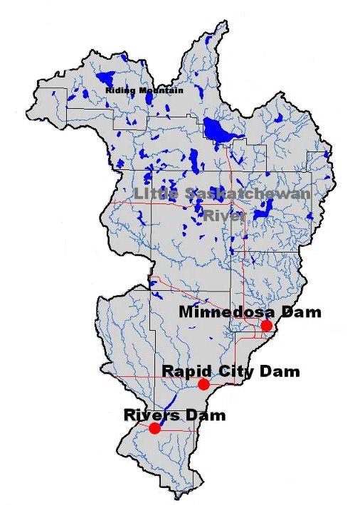
The Little Saskachewan River starts in Lake Audy at Riding Mountain National Park and travels about 185 km south through Minnedosa and Rapid City. It also joins the Assiniboine River about 10 km west of Brandon.
The entire watershed is about 3,600 square kms and includes three dams and reservoirs, including Minnedosa, Rapid City and Rivers. Lake Wahtopanah is also part of the watershed.
The dams were all inspected in June and were up to par, said Schuler.
Asked what would be at risk should the dam fail, Schuler simply said “everything in its path.”
Rivers resident Cassandra Lepp told 680 CJOB that the flooding in the community has been “horrendous”.
“We’re pretty sad… a lot of our neighbours that we’ve had for 30 years, their houses are underwater. It’s really heartbreaking.
“If that dam goes, it’s going to be so much more damage for people.”
Lepp said if the dam does fail, her property is one of those would be affected by the water almost immediately.
“If it went fast, it would be minutes — seconds, I would say.
“I don’t think anyone’s ever thought about this dam failing, because it’s so overbuilt — the military built it — and it’s never been anywhere close to this high.”
RM of Riverdale mayor Todd Gill said 38 properties in his community — including his own — had already been evacuated as of Thursday morning.
“To put it in perspective since Sunday when the storm started, Lake Wahtopana rose nine feet… which is unimaginable. Nobody has ever seen that before and nobody thought it was possible.”
Gill’s own home, on the lake, was evacuated despite the efforts of about 50 community members.

“We lost the fight about 1:30 Wedneday morning… the waves came over the dam, and we conceded to the water. We shut the power off and left,” he said.
“Right now we have to deal with the emergency order in front of us and make sure we prevent further loss.
“Certainly, we’ve got lots to mourn, but right now, we’ve got a critical task ahead of us, and we’re going to focus on that until we get through this — and we will get through it. Then we’ll deal with our own personal situation.”
Gill said his understanding is that other residents along the lake — also known as Rivers Reservoir — are currently secure, as long as the water doesn’t rise, but the immediate threat relates to the structural integrity of the dam.


Downstream in Brandon, the Assiniboine River is high and is expected to peak in the next few days between 14,000-18,000 cubic feet per second.
At the moment, households in Brandon are not being evacuated, but Mayor Rick Chrest said houses in low-lying areas are being told to prepare to leave if necessary.
The city reactivated its emergency operations centre a few days ago, he added.

“The decision was made to put it in what we call ‘The Plug’ at 18th Street and Grand Valley Road.
“The Plug” is a temporary dike at that intersection that keeps water from spilling into the city, he said, although it means some households living on the street will have to find another way into the city.
The temporary dike will take about eight hours to complete, said Chrest.
Asked about the cost of the operation, Schuler said they’re more concerned that families and livestock are safe.
“We cannot take chances with the incredible amount of water creating pressures on the Rivers dam,” he said.
After a few days, engineering teams should be able to see the bottom of the dam and do an assessment. In the meantime, the dam will be fortified.
“As we’re speaking right now, truckloads of rock are being brought in and being dumped in on either side,” said Schuler.

The watershed has several dams to control waterflow during heavy times and they are all being inspected and monitored, he said
Asked if he could recall people being evacuated due to overland flooding because of rain in Manitoba, Schuler said he’s been an MLA for 21 years.
“One of the first ones I know in my history … this is fairly unique.”
-With files from Abigail Turner
Comments