
Sea-level areas of Metro Vancouver won’t see snow after all Thursday night, but the rest of B.C. hasn’t been as lucky.

And the South Coast will still see heavy rain that could add up to 80 millimetres by Friday night.
That’s according to the updated weather warnings from Environment Canada, which issued snowfall and rainfall warnings for a vast swath of the B.C. coast and interior to begin Thursday morning.
You can see an up-to-date list of alerts here.
The major low pressure system hit Vancouver Island and the Sunshine Coast Thursday morning and had spread into the Sea-to-Sky corridor and Metro Vancouver by late morning.

BC Hydro is also warning that the storm could bring strong winds to Vancouver Island and the South Coast, potentially knocking out power, just days after more than 120,000 customers lost power in the Interior due to heavy snowfall.
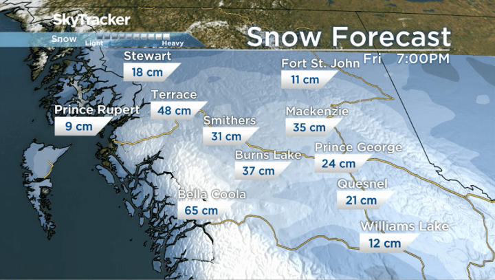
On the North and Central Coasts, Environment Canada has issued winter storm warnings, and says between 30 and 60 centimetres (one to two feet) of snow could fall by Friday.
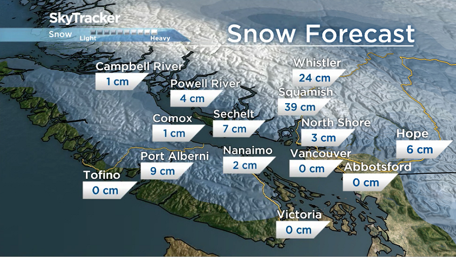
In Metro Vancouver, higher elevations could see anywhere from two to 10 centimetres of snow. While there was a chance of snow for lower elevations, only rain ended up falling.
Snow began to fall on Burnaby Mountain Thursday evening, as well as in Coquitlam and into the Fraser Valley, including Abbotsford and Chilliwack.
While the snow in Abbotsford may not stick at lower elevations, parts of the Fraser Valley lying further east, including Hope, could see six centimetres of snow.

Get breaking National news
On Vancouver Island, the eastern central and northern coasts were seeing “moderate” snowfall Thursday afternoon evening, with drivers facing whiteout conditions on the snow-covered highways.
Higher elevations on the island were expected to get between two and 10 centimetres of snow.
The Sea-to-Sky corridor could see anywhere from five to 25 centimetres of snow, while higher elevations of the Sunshine Coast could also receive two to 10 centimetres.
Drivers on the highway outside Squamish — which could receive just under 40 centimetres by Friday — were seeing heavy snow after the sun set Thursday.
Motorists taking the Sea-to-Sky Highway are being advised to prepare for challenging conditions, and take it slow on the road.


Highway drivers should also have an emergency kit, including a shovel, ice scraper, snow shovel, sand, and snow chains.
Environment Canada has also issued a rainfall warning for parts of Metro Vancouver and Howe Sound, and says between 60 and 90 millimetres of rain could fall by Saturday.
But the snow won’t last long. Temperatures warm up across the entire South Coast late tomorrow evening and the rain will wash it all away.
This same system will also hammer the Interior beginning late tomorrow and continue through much of Friday.
Another two to 20 centimetres of snow is possible across the south, with even more expected in central and northern B.C. regions.
“The approaching storm will give widespread snow into the Interior this evening,” Environment Canada said in its wide-ranging special weather statement.
“The main band of snow will shift northwards on Friday morning, allowing the snow to come to an end for communities in the Okanagan, South Thompson, and Kootenays. However over the Columbias, the Central and Northern Interior, the snow will continue all day.”
The national weather service added that the highest snowfall amounts are expected to be over the Bulkley Valley, McGregor, Yellowhead and Williston regions.
It also said there is a chance of freezing rain for the Central Interior as the band of snow pushes northwards on Friday morning.
Comments
Want to discuss? Please read our Commenting Policy first.