

Hot on the heels of the region’s biggest snowfall of the season, B.C.’s South Coast faces more snow Sunday.

Environment Canada has issued snowfall warnings Metro Vancouver and southern and all of Vancouver Island save for the northern section, while and a winter storm warning was issued for the Fraser Valley.
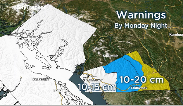
In Metro Vancouver, the agency is forecasting 10 to 15 cm of snow is forecast.
“Areas inland and those in the path of the Fraser Valley outflow winds particularly can expect snow to continue through Monday,” Environment Canada said.

Get breaking National news
“Snowfall amounts will vary due to the timing of the transition and are likely to be much higher over higher terrain, as the rain-snow line is expected to fluctuate between sea level and 200 metres (Sunday night) and Monday.”

- Severe thunderstorms and tornadoes possible across Alberta, in Edmonton region Tuesday
- 2026 is the wettest summer on record in Edmonton — with more storms expected
- France order 4,000 more evacuations as fires ravage southwest Europe
- Monday thunderstorm floods roads, halts traffic and transit across Edmonton


Victoria was forecast to see between five and 10 cm of more snow, while inland parts of the island could see between 15 and 25 cm by Monday morning.
In the Fraser Valley, winter conditions are forecast to persist into Tuesday.
Environment Canada said between 10 and 20 cm of snow was possible by Monday afternoon and warned periods of freezing rain were also likely Sunday night through Monday morning.
Temperatures in the region are expected to return to seasonal average by mid-week.
TransLink reported no major disruptions Sunday morning but advised passengers to plan extra time into their commute and to keep an eye on its Twitter feed for service updates.
Anyone venturing onto the roads is reminded that they must have snow tires equipped and know how to drive for the conditions.
Comments
Want to discuss? Please read our Commenting Policy first.