


Rain moves in as the weekend begins! Find out if it sticks around.

Special Weather Statement

A low pressure system developing in Montana will track northeastward and lie over east central Manitoba by Sunday morning.
An area of rain and embedded thunderstorms will develop along and just to the northwest of the track of the low overnight and through the day on Saturday.
As this system slows down by Saturday night rainfall will become more widespread and increase in intensity.
The heaviest rainfall will be over east central Saskatchewan where rainfall amounts of 30 to 40 mm will be widespread with locally higher of 50 to 60 mm possible under the thundershowers by Sunday morning.
With the recent significant precipitation any rainfall will lead to heightened concerns for flooding.
Severe Thunderstorm Watch
Environment Canada has issued severe thunderstorm watch for the Biggar, Rosetown, Kindersley, Leader, Gull Lake, Swift Current, Cypress Hills and Maple Creek areas.
Conditions are favourable for the development of dangerous thunderstorms that may be capable of producing damaging wind gusts, damaging hail and heavy rain.

Get breaking National news
A low pressure system approaching from western Montana will trigger thunderstorms within a very unstable airmass late Friday afternoon.
Some of these thunderstorms may become severe as they move northeast.
For the latest weather alerts download the Global News Skytracker weather app for iPhone, iPad or Android.
Saskatoon Forecast
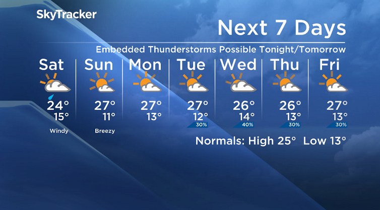
Today
The day began under mostly sunny skies with temperatures dropping to around 11 degrees to start.
We quickly warmed up into the low 20s by 10 a.m. with a few more clouds building in midday.
Clouds will continue to roll in this afternoon as a low pressure system moves into the province and temperatures rise up back into the mid-to-high 20s.
Tonight
Rain will move in late this evening and stick around overnight with some embedded thunderstorms possible as the mercury falls back into the mid-teens.
- After major snow and flooding in Saskatchewan, wildfires are on the map
- ‘Hottest air we’ve seen so far this year’ triggers heat warnings in Saskatchewan, Manitoba
- Environment Canada issues heat warnings for large parts of Alberta, Saskatchewan
- Intense European heat wave scorches as multiple countries report deaths


Saturday
The weekend kicks off on a wet note with rain to start the morning with a few thunderstorms possible before it begins to taper off through the day.
There is a chance of a few thunderstorms later on in the afternoon as well.
Temperatures may only top out around 23 degrees or so, depending when the rain stops.
As the low pressure system swings through during the day, winds will pickup from the northwest at sustained speeds up to 30 km/h with gusts upwards of 40 km/h at times.
Sunday
Upper ridging moves back in for Sunday, clearing skies back out to give us a beautiful, sunny day.
Temperatures will also recover nicely with an expected daytime high around 27 degrees as winds ease back into the 15 to 20 km/h range.
Work Week Outlook
It looks as though the sun-lover’s friend, the upper ridge of high pressure, will stick around through next week keeping us warm with daytime highs in the mid-to-upper 20s with the a chance of thunderstorms on a few days.
Early indications are also hinting at the potential for that trend to stick around into the long weekend, but we’ll keep our eye on that – it’s still a ways away.
Lucas Winiewski took this Your Saskatchewan photo near Moose Jaw:

Saskatoon weather outlook is your one stop shop for all things weather for Saskatoon, central and northern Saskatchewan with a comprehensive, detailed look at your local forecast that you can only find here.


Comments
Want to discuss? Please read our Commenting Policy first.