A “major winter storm” is set to impact southern Ontario beginning on Wednesday and continuing into early Thursday.

Global News meteorologist Anthony Farnell said snow will first begin across southwest Ontario during the morning and spread into the Toronto area by the early afternoon.
“Conditions will quickly deteriorate as the snow intensity increases during the afternoon commute,” Farnell said.
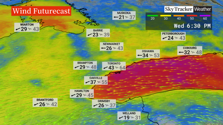
“Snowfall rates could reach 2 or 3 cm per hour and winds will gust over 60 km/h near the Lake Ontario shore, which will create near-zero visibility with blowing snow.”
Initially the snow will be wet which might reduce blowing snow, but colder air will filter in as the day progresses, he said.
“If you can work from home or leave early, Wednesday would be the day to do it,” Farnell said.
It will be the “biggest snowstorm of the winter so far” in the Greater Toronto Area, with up to 25 cm likely by Thursday morning, he added.
- ‘Lightly felt’: Magnitude 3.7 earthquake gently rocks southern Ontario
- Toronto sidewalk clearing needs improvement after snowstorm, city officials say
- Police launch investigation into 2nd recipient of Ford government skills development fund
- Record 28.2M Toronto tourists generated $9.1B in spending last year: report
For areas in eastern Ontario and into southern Quebec, from Ottawa to Montreal, 30 cm is possible with snowfall lingering through Thursday.

Get daily National news
Environment Canada placed a large portion of southern Ontario and parts of Quebec under a special weather statement ahead of the system. On Tuesday afternoon, most of the weather statements were replaced with snowfall warnings, stretching from Windsor up into southern Quebec.
The Greater Toronto Area and Hamilton are among the areas under the snowfall warning.
Heading into the weekend, another snowstorm is likely on Sunday for southern Ontario.
There will be colder air in place, meaning the snow that falls will be light and fluffy, Farnell said.
That system could bring an additional 10 cm.


Comments