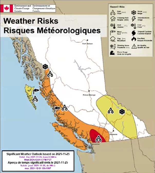
Flood-ravaged communities across southern B.C. are not out of the woods yet, Environment Canada warned, as back-to-back atmospheric rivers approach.

The first storm will bring heavy rainfall on Saturday and Sunday, and the second will strike next Tuesday and Wednesday.
“We are now in recovery mode and we still have dangerous weather ahead,” said warning preparedness meteorologist Armel Castellan in a Friday update.
“The worst case scenario is still not super likely for Tuesday and Wednesday being as bad as what we saw in the middle of the month, but it does exist.”

The storms, combined with the already drenched and vulnerable landscape, has led the federal department to issue its first “red level alert.”
That system didn’t exist during the record-breaking and deadly B.C. heat wave or wildfires over the summer, Castellan added, or it would have been issued then.
“I would say this alert is really due to the vulnerabilities that are present on the ground, particularly in the Fraser Valley where we have the Sumas Prairie still recovering from the previous event … as well as right into our southwestern Interior, where we obviously have a susceptible landscape to debris flow and slides.”

The heaviest rain will be Saturday night and will begin to ease Sunday afternoon, Environment Canada forecasts.

Get breaking National news
Between 60 and 80 millimetres could fall in Gibsons and the areas from Vancouver to the Fraser Valley. Up to 100 mm could fall closer to the mountains in the Lower Mainland, while Squamish could see up to 120 mm.
Snowmelt will exacerbate the impacts of the storm, warned Castellan, increasing the risk of flooding and landscapes on already saturated land and infrastructure.

- Recently launched app rates wildfire risk for properties across Canada
- Ottawa to contribute $29M to carbon capture, renewable energy projects
- Another oil pipeline through B.C. sees renewed interest as Enbridge CEO weighs in
- Gob the Vancouver Island marmot journeys back to breeding centre after release
“These are coming back to back to back with very little time in between,” he explained.
“We’ve had an extraordinarily wet fall, the the landscape is completely saturated — any extra moisture runs down more easily and much quicker.”
British Columbia usually experiences more than 10 atmospheric rivers a year, mostly between November and January. Saturday’s will be the seventh of the season, meaning they’re striking earlier and with more intensity, said Castellan.
The rivers tap into subtropical moisture near the equator and sweep across the Pacific Ocean — normally in a northeasterly direction — to hit the West Coast of Canada and the United States.
“These are extraordinary times, definitely,” said Castellan, noting that many weather stations in Victoria, Abbotsford, Vancouver and other parts of the Lower Mainland have observed the wettest falls on record.

Residents in alert areas for this weekend are being asked to prepare to evacuate if needed, with a fuelled up vehicle and emergency supplies on hand.
The B.C. Ministry of Transportation is also asking drivers to observe caution on the roadways, and only travel for essential purposes.
The province may announce additional road closures on Saturday, it said, and a travel advisory has been issued for commercial vehicles heading toward the Lower Mainland. Drivers are asked to avoid travelling past Kamloops to avoid excessive congestion in Merritt.


Comments
Want to discuss? Please read our Commenting Policy first.