
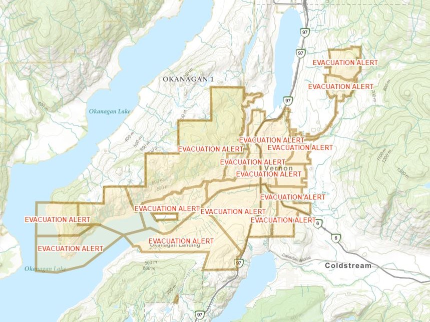
UPDATE: The City of Vernon has updated its evacuation alert issued earlier in the day.

The alert now includes most of the city, barring a few neighbourhoods.
“The decision to expand the alert was made out of an abundance of caution based on the advice of BC Wildfire Service, due to increased fire activity and increased ember debris from the White Rock Lake wildfire,” the city said in a press release at 10:43 p.m.
According to the city, the excluded neighbourhoods are:
- Predator Ridge and Sparkling Hill neighbourhoods
- Okanagan Landing South neighbourhoods (areas of Eastside Road, The Outback, Ellison Provincial Park Inkster, Delcliffe, Whitepoint, Smith Road, Peters Road, Kokanee/Sunset properties, Harbour Heights, Beverly Hills Estates)
- Commonage Area, south of Bench Row Road
ORIGINAL STORY:
The City of Vernon says it has issued an evacuation alert for certain areas within city limits, northeast of Okanagan Lake, because of the White Rock Lake wildfire.
The city says it is advising residents in the communities of Canadian Lake View Estates, Adventure Bay, Tronson Road, Rise, Turtle Mountain and Blue Jay, and that residents there should be on heightened alert.
“Residents in the identified areas are being asked to prepare for an immediate evacuation should an evacuation order be issued,” the city said on Friday afternoon.
“That includes arranging accommodations prior to an evacuation order.”
According to the BC Wildfire Service, the White Rock Lake wildfire is displaying increasingly aggressive fire behaviour, which may result in ember showers that could result in spot fires.
The out-of-control fire is estimated at 45,000 hectares. On Thursday, its size was listed at 32,500 hectares.

Get daily National news
“Large fires like the White Rock Lake wildfire often create their own weather patterns,” said Vernon fire chief David Lind.
“Sometimes with that comes an increase in debris being cast across a significant distance. Sometimes that debris can be large enough and hot enough to create an ember fire.”

The city says it will continue to monitor the fire, with crews keeping close attention on possible ember fires in the identified areas, “with a specific focus on Tronson Road, Adventure Bay, and Canadian Lake View Estates due to weather projections.”
According to the city, residents should be advised Vernon Fire Rescue Services will be strategically stationed along Tronson Road in the event of spot fires.
Crews will be positioned along Tronson Road and circulating through Adventure Bay and Canadian Lakeview Estates throughout Friday afternoon and evening.
“We ask that all residents maintain a heightened awareness of the evolving situation over the next 24 hours, watch for spot fire caused by embers,” said the city, “and should be prepared in advance for a potential evacuation order.”

In related news, the Regional District of North Okanagan (RDNO) is urging residents to follow evacuation orders if their properties are affected.
“When an evacuation alert is issued, it means we want residents to get prepared to leave should things progress,” the RDNO said in a press release on Friday.


“When an evacuation order is issued it means there is a direct threat to human life and safety. Remaining in an evacuation order area puts first responders at tremendous risk, as well as the life and safety of residents choosing to stay behind.
“When this happens efforts are taken away from actively suppressing the fire and protecting structures, and are redirected towards tactically evacuating those who choose to remain in their homes.”

RDNO chief administrative officer David Sewell added, “Wildfires are extremely unpredictable and should not be taken lightly. We just want to ensure everyone stays safe and that the BC Wildfire Service can complete suppression efforts as efficiently as possible”.
The Regional District of North Okanagan currently has three fires of note in the area, including White Rock Lake, Bunting Road and Winnifred Creek.
Also Friday, the Okanagan Indian Band (OKIB) released an afternoon update, stating the blaze is very aggressive and that it expects the fire to reach Whiteman’s area in the evening.
“As of this moment, we have not lost any buildings to the fire. However, that could change today,” said the OKIB.
“The fire jumped Highway 97 yesterday at Monte Lake, wiping out the community. There may not be much time between the evacuation alert and the evacuation order, so people in the evacuation alert area should be ready to leave so please tell your friends and family to get their go-bags prepared.”

Also on Friday, the Columbia Shuswap Regional District (CSRD) said there had been a tactical evacuation of 10 properties in the Six Mile Creek Road area, and that an evacuation order was issued at 5 p.m. for the area.
The CSRD said the fire’s growth has been predominantly in the northeastern and eastern flanks, with some growth along the southeast flank.
The most northern flank is approximately 13 km southeast of Pritchard.
The most southeastern fire perimeter is approximately five km west of Westside Road.
“The winds have been stronger and more sustained than previously predicted,” said the CSRD. “This evening, gusts upwards of 40 km/h are expected. This will significantly impact fire growth and behaviour.”
Comments
Want to discuss? Please read our Commenting Policy first.