


Tornado watches were issued for parts of central Alberta on Thursday as severe weather hit parts of the province.

A tornado watch was issued at 5:30 p.m. Thursday just south of Edmonton for the areas in and around Leduc, Beaumont, Camrose, Wetaskiwin and Tofield, and then shortly after 7 p.m. in central Alberta near Red Deer and Drumheller.
The tornado watch issued for just south of Edmonton was lifted on Thursday evening. As of 8:45 p.m., the tornado watch for the Red Deer area has also been lifted, however, the watch for the Drumheller area remained in effect for a while longer before eventually being lifted as well.
The weather on Thursday presents dangerous and potentially life-threatening situations in some areas, Environment Canada said, explaining conditions are favourable for the development of severe thunderstorms which may produce tornadoes.
The weather agency advised people to be prepared for severe weather and to take cover immediately if threatening weather approaches.
Environment Canada said if the tornado watches are upgraded to a warning in an area, people should go indoors to a room on the lowest floor, away from outside walls and windows, such as a basement, bathroom, stairwell or interior closet.
In such a situation, people should leave mobile homes, vehicles, tents, trailers and other temporary or free-standing shelter, and move to a strong building if possible.
As a last resort, people should lie in a low spot and protect their head from flying debris.
Tornado watches are issued when atmospheric conditions are favourable for the development of thunderstorms that could produce tornadoes.

Late Thursday afternoon, a severe thunderstorm warning was issued for Edmonton. The storm pummelled parts of the city with heavy rain and hail and even caused some damage to Rogers Place before the warning was downgraded to a watch.
READ MORE: Edmonton’s Rogers Place damaged by ‘significant storm’
Some roads were flooded. ENCOR by EPCOR tweeted Thursday evening that the Whitemud Drive underpass at 106 Street was closed because of flooding early Thursday evening.
About 55 kilometres south of Edmonton, the town of Millet was hit hard by Thursday’s powerful storm. Strong winds appeared to have ripped the roof off of the town’s water reservoir. A town official told Global News that Millet’s water supply has not been compromised despite the damage to the facility.

Get daily National news
Other roofs in the town were also damaged and a Global News crew at the scene witnessed many downed trees and power lines.
For a complete list of weather warnings, watches and advisories in effect for Alberta, click here.
This is a developing situation and the story will be updated as conditions change.
Previous story:
The city of Edmonton and surrounding regions were put under severe thunderstorm warnings just before 5 p.m. Thursday, as thunderstorms swept through the area.
At around 4:45 p.m., Environment Canada meteorologists were tracking several storm cells in the area, including one over Edmonton heading northeast at 20 km/h, and another near Calmar heading northwest at 15 km/h. Both were capable of producing very strong wind gusts, up to nickel size hail and heavy rain.


A line of fast-moving storm cells could be seen on radar moving from the foothills northeast towards Edmonton and beyond.
It was one of several storms Environment Canada expected when it issue severe thunderstorm watches earlier in the day for a large section of central and southern Alberta, including Calgary and Edmonton. The weather agency also said there was a risk of tornadoes Thursday.
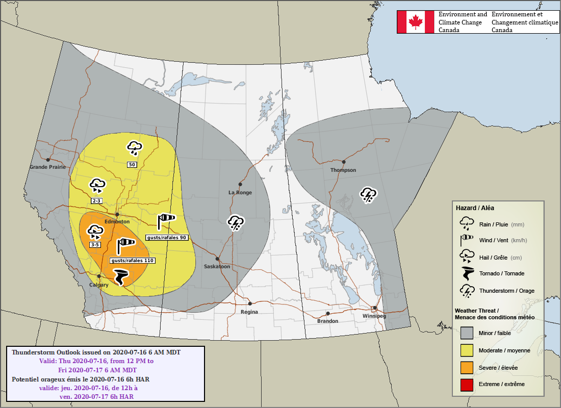
The Environment Canada thunderstorm outlook predicted storms over most of the province, with severe weather most likely over central regions beginning in the afternoon.
The national weather agency issued the watches (scroll down for a list of affected areas) just after 11 a.m., saying conditions were favourable for the development of dangerous thunderstorms capable of producing strong wind gusts, damaging hail and heavy rain.
The storms could produce up to five centimetre (egg-to-tennis ball size) hail, 50 mm rainfall, and wind gusts to 110 km/h with a chance of a tornadoes, the outlook said.
“Thunderstorms will develop along the foothills this afternoon and evening and will move eastward,” the watches stated. “Some of these thunderstorms may become severe.”
Environment Canada said current guidance suggests the highest tornado risk is for areas east of Calgary, and said it expected to further expand the area covered by the watches on Thursday afternoon.
Severe thunderstorm watches are issued when atmospheric conditions are favourable for the development of thunderstorms that could produce large hail, damaging winds and/or torrential rainfall.
The showers and thunderstorms are expected to weaken or exit Alberta after midnight, however a secondary area of thunderstorms is expected to develop Thursday night over central regions with a risk of two-centimetre hail.
“Confidence in both thunderstorm development and storms reaching severe criteria is high during the day and low-moderate for the overnight period,” the thunderstorm outlook said.
Read more: Northeast Calgary residents warned of fly-by-night contractors in wake of devastating hailstorm
Areas covered by the watch in the early afternoon included Airdrie, Cochrane, Olds, Sundre, Brooks, Strathmore, Vulcan, Drayton Valley, Devon, Rimbey, Pigeon Lake, Drumheller, Three Hills, Leduc, Camrose, Wetaskiwin, Tofield, Okotoks, High River, Claresholm, Red Deer, Ponoka, Innisfail, Stettler, Rocky Mountain House and Caroline.
It was later expanded to include the City of Edmonton and surrounding region, including St. Albert, Sherwood Park, Spruce Grove, Morinville, Mayerthorpe, Evansburg, Fort Saskatchewan, Vegreville, Redwater and Smoky Lake.
To report severe weather in your area, you can email ABstorm@canada.ca or tweet using the hashtag #ABStorm.
— With files from Melissa Gilligan, Global News
Comments
Want to discuss? Please read our Commenting Policy first.