

Ottawa’s public health unit is showing which wards have the highest number of residents testing positive for the novel coronavirus, though officials caution the new map will not reveal “COVID-19 hot spots” in the capital.

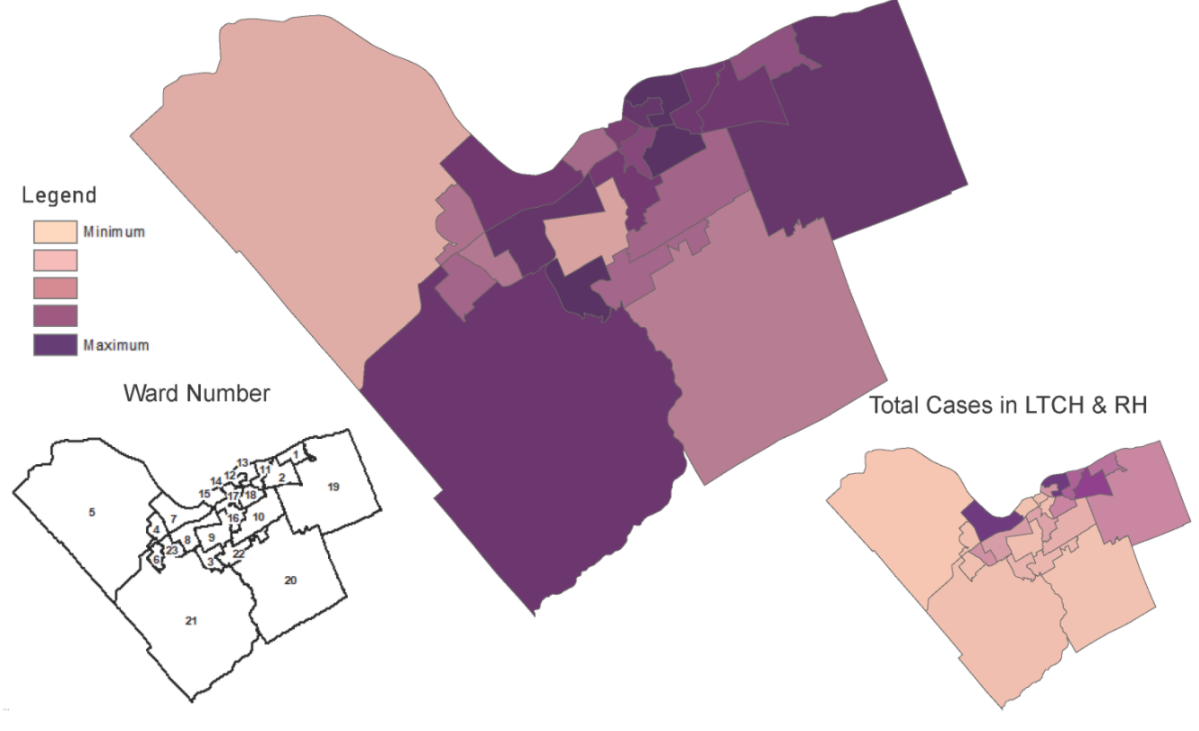
Ottawa Public Health’s (OPH) new map will update biweekly to show a snapshot of lab-confirmed cases per 100,000 people in the nation’s capital, based on where positive-testing residents live.
Data is divided by wards and is filtered to exclude long-term care homes and retirement residences where outbreaks of the novel coronavirus might inflate infection rates.

The first snapshot from May 19 shows the highest number of cases per 100,000 residents in Rideau-Rockcliffe (139), Alta Vista (130) and Barrhaven (122), while West Carleton-March (51) and Knoxdale-Merivale (55) report the fewest.
Dr. Vera Etches, the city’s medical officer of health, told members of the media during a conference call Wednesday afternoon that Ottawa Public Health’s map is not meant to show “hot spots” for the virus or where residents are more or less likely to be infected.

Get weekly health news
The data in the map shows only where residents with COVID-19 live, not where they contracted the disease or have travelled since.
The main thing the map shows is that the virus is everywhere in Ottawa, Etches said, and apart from that, there is little valuable information to be discerned from the limited snapshot.
“COVID is everywhere in our community. It crosses our geography,” she said.
“That’s really the only valuable thing the maps can tell us.”
OPH released the map more as a gesture of transparency and less in hopes of giving residents new information to guide their day-to-day actions.
The local public health unit reported 25 new cases of the virus in Ottawa on Wednesday, bringing the local total up to 1,849.
Eight more people died as a result of COVID-19, raising Ottawa’s pandemic death toll to 210.


Among the latest deaths is a worker at the Peter D. Clark long-term care facility.
This marks the second death of a front-line care worker at an Ottawa long-term care residence and the first city employee to pass away as a result of complications from COVID-19.
Mayor Jim Watson confirmed during Wednesday’s media call that the city will extend its ban on event permits until Aug. 31, effectively putting an end to the summer festival season in Ottawa, which had already seen the cancellations of Canada Day celebrations and Bluesfest.
Watson did mention that he has directed staff to explore recommendations for closing additional city streets to allow some restaurants to consider implementing “pop-out patios.”
He said that restaurants are likely to struggle when they’re eventually allowed to reopen for dine-in meals as physical distancing measures will be difficult to implement in enclosed spaces, so expanding their dining rooms into the street could provide a much-needed boost.
Watson also unveiled a new reopening toolkit for businesses in Ottawa, many of which have been starting up again as of Tuesday.
The new resource provides signage and recommendations for businesses to help them reopen safely and protect customers during the pandemic.
Comments
Want to discuss? Please read our Commenting Policy first.