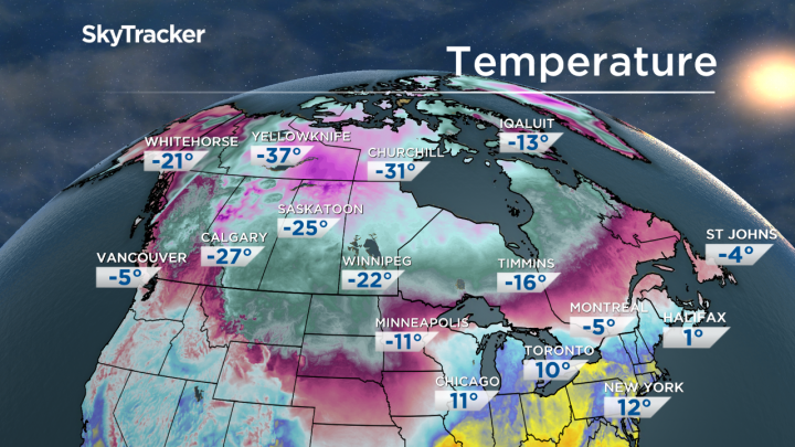
Winter weather has settled over Western Canada after hitting central and eastern parts of the country in late January.

Temperatures plummeted in parts of British Columbia and Alberta over the weekend and continued into Monday.
Global News meteorologist Ross Hull explained what they’re getting is essentially a taste of the polar vortex that Ontario and Quebec dealt with last week.
“The polar vortex is basically cold air that builds over the Arctic – depending on the weather pattern, that air can then move into different parts of the country,” Hull said.
“This week, the upper-level flow of the atmosphere is directing it towards Western Canada – giving Canadians there a taste of the polar vortex.”
WATCH: Warming centres open across Metro Vancouver due to cold weather

Winter warning for Metro Vancouver
Arctic air is blasting out of the B.C. interior, and Metro Vancouver and the Fraser Valley are feeling the worst of it.
The Fraser Valley is feeling wind chills of -18 to -22 on Monday.
READ MORE: Cold weather hits Metro Vancouver and the Fraser Valley
Environment Canada currently has a special weather alert for Metro Vancouver, which explains the residents should expect “cold and blustery outflow winds.”
The alert notes that the area’s temperatures will slowly rise in coming days, but remain below seasonal norms. Some flurries are expected, but no snow accumulation.

Get breaking National news
That’s quite a dramatic change from the weather in the area just days ago, when Vancouver residents reported spring-like weather. Some even boasted that they were beginning to see flowers blooming.
WATCH: How to keep dogs warm this winter season

Prairies hit with extreme cold
It’s even colder in Calgary, where an extreme cold-weather alert notes the city will see wind-chill values between -40 and -45.
“These extreme wind chills will moderate through the day slightly, however, the extreme wind chills will persist in the overnight periods into Tuesday,” Environment Canada said.
READ MORE: Calgary weather — Extreme cold sparks school closures, bus cancellations
Most of Alberta is under an extreme cold warning, while northern Saskatchewan and parts of Manitoba are under cold and snowfall warnings.
Mild temperatures in Eastern Canada
Temperatures in Eastern Canada were also higher than normal. It was just -1 C in Halifax and -4 C in Charlottetown.
While there was a special weather warning for parts of New Brunswick due to icy conditions, the temperature in Fredericton was milder than expected at 3 C.
WATCH: Biggest January storm hits Toronto in five decades

Spring-like conditions in Toronto
It seems that spring-like weather from Vancouver decided to travel across the country.
On Monday morning, southern Ontario saw temperatures well above zero — it was 8 C in Toronto.
READ MORE: It’s getting so cold in parts of southern Ontario, there’s a risk of frostbite
Hull explained this switch in temperatures was just after Toronto saw its coldest January in years. The current warmer temperatures are part of the what’s known as “February thaw.”
And it won’t last.
“This February thaw will start to come to an end as soon as Tuesday,” Hull explained, noting that doesn’t necessarily mean extreme cold will return right away.
There will be a risk of ice pellet and freezing rain in Toronto later this week. By the weekend, it will be much colder, Hull said.
WATCH: When will winter end? (according to rodents)

What’s in store?
Hull said Western Canada will remain cold and experience below-average temperatures up until mid-February, but it will stay quite dry.
In Eastern Canada, the meteorologist said there could be “messy winter weather” in store, including freezing rain.
READ MORE: January weather in Canada — Flowers are blooming in the west and snow is pummeling the east
“The mild pattern will be replaced by the polar vortex making a return at times and with that cold air in place, there will be the potential for more snow and mixed precipitation,” Hull said.
Looks like winter is sticking around.


Comments
Want to discuss? Please read our Commenting Policy first.