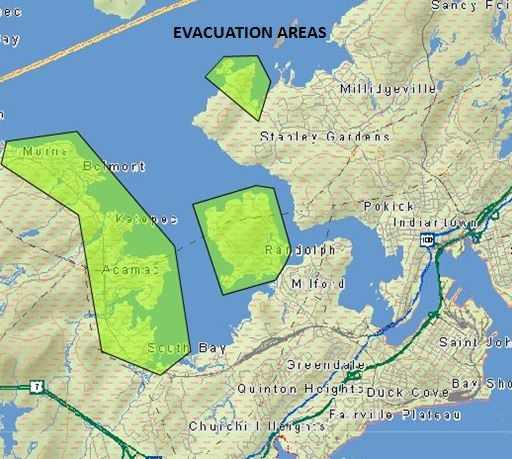
The City of Saint John has issued a voluntary evacuation notice to an estimated 1,900 people in the region as a result of rising flood waters.

The city says that the water levels on the Saint John River are close to five metres and are expected to creep even higher, possibly reaching 6.6 metres by Sunday — exceeding the catastrophic flood levels experienced by the city in 2008 by more than a metre.

Saint John has issued the evacuation notice for the following areas:
- Randolph – those living past the Randolph Bridge
- Westfield Road area (South Bay to Morna) – specifically those living between the Gault Road and the eastern end of Mellinger Crescent
- Ragged Point Road – those living past the St. Francois De Sales Church
- Beach Road
- Any isolated areas along the St. John River within the City of Saint John

Get daily National news
WATCH: Drone footage shows extent of rising flood waters in Fredericton

Mayor Don Darling says that the next few days will be all hands on-deck.
“The men and women have trained for this, they’re experts at it,” he said.
“They know what to do, and to the best of our ability they will do what we can.”
Although the evacuation order is voluntary, the city says that “emergency access and local traffic to these areas is now limited and is expected to be completely cut off due to increased flooding.”
Citizens are asked to make accommodations with family and friends but if are unable, can visit the Reception Centre at the Carleton Community Centre, 82 Market Place West to receive assistance.
The centre will be open until 10 p.m. Tuesday and will reopen at 8 a.m. on Wednesday.
The city recommends evacuating with pets as well as the following supplies:
- A week’s worth of clothing
- Medications
- Identification, cash, and keys
- Pets, their food, carriers and medical history/list of vaccinations
WATCH: Flooding forces evacuations in some communities in N.B.

If you do evacuate, the city of Saint John is asking that you register with the Canadian Red Cross by calling 1-800-863-6582 so that they can make sure people are safe.
Road closures are expected to expand as the flood waters continue to rise throughout the week, likely causing some homes to become isolated for at least seven days.
“Emergency services will have limited ability to respond and reach residents who chose to stay in these areas during this time,” said the city.


Comments
Want to discuss? Please read our Commenting Policy first.