

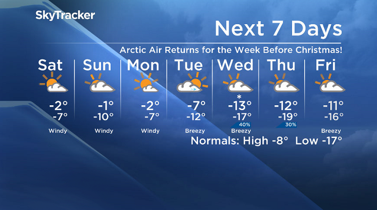
Arctic air returns just in time for the week before Christmas!

Saskatoon Forecast
Friday
A bit of light snow and rain started off the day with temperatures popping up to the freezing mark and just above by morning, preventing any freezing rain from developing.
We warmed up just a bit by midday with the mercury reaching +2 by noon under mostly cloudy skies.
Clouds will continue to dominate the remainder of the day with just a slight chance of rain as spring up even further to an afternoon high a degree further into the positive zone.

Get daily National news
Friday Night
There is a decent chance of showers, switching to flurries this evening as a disturbance and cold front ripples through before clouds start to clear out overnight as we cool down into mid-minus single digits.
Saturday
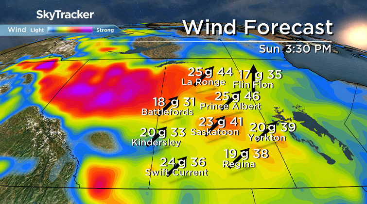
Winds will remain breezy on Saturday behind that front on Saturday with wind chills making it feel like the minus teens to start before temperatures rebound up toward, but just shy of the freezing mark in the afternoon.
A low pressure system to our north will keep clouds in that area with Saskatoon expected to be on the edge of that deck, so a mix of sun and cloud is on tap for the day.

Sunday
A few breaks of sunshine are possible on Sunday early in the morning before the clouds roar back in along with some breezy winds with the next wave of Pacific moisture pushing in.
Temperatures will start off close to or possible even into minus double digits with wind chills making it feel near -20 to start before the mercury rises up toward the freezing mark in the afternoon.


Work Week Outlook
A cold front sweeping through Sunday night will drop us into a much cooler zone for the week before Christmas with daytime highs dropping from minus single digits Monday into minus double digits by mid-week.
Morning wind chills will dive into the mid -20s with clouds rolling in mid-week with a chance of flurries after a sunny and windy start to the week with gusts upwards of 60 to 70 km/h on Monday.

Hamilton Greenwood took the Dec. 15 Your Saskatchewan photo near Prince Albert.
Saskatoon weather outlook is your source for Saskatoon’s most accurate forecast and is your one stop shop for all things weather for central and northern Saskatchewan with comprehensive, in depth analysis that you can only find here.
Comments
Want to discuss? Please read our Commenting Policy first.