Wildfires across British Columbia forced thousands to flee their homes over the weekend.

Thousands of residents were ordered to leave the central interior city of Williams Lake and numerous communities surrounding it on Saturday night as fire lines threatened to cut off nearby highways.
A series of other evacuation orders were issued Saturday as hot, windy weather fanned flames across the province.
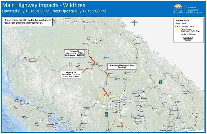
Wildfires have also led to a series of road closures.
According to Drive B.C., “traffic is being directed south on Highway 97 due to the closure north of Williams Lake. That traffic will then travel Highway 24 to Little Fort and down to Kamloops. We have confirmed traffic can travel south through the fire area north of 100 Mile House.”
Here is a list of road closures and partial closures as of Sunday, July 16:

Get daily National news
– Highway 1 from the Highway 97C junction near Ashcroft to about 5 kilometres east of Cache Creek
– Highway 97 from Cache Creek to Clinton
– Highway 99 from Highway 97 Junction to Hat Creek Road. Local Traffic only from Lillooet to Hat Creek Road
– Highway 97 from junction of Highway 24 to Timothy Lake Road (25 kilometres north of 100 Mile House), but open southbound for evacuees
– Highway 97 from Williams Lake to McLeese Lake
– Highway 5A between Princeton and Allison Lake
– Highway 97 southbound between Kersley (15 kilometres south of Quesnel) and McLeese Lake
– Highway 20 is open to eastbound traffic only. It’s closed to westbound traffic (except emergency vehicles and first responders) at the Sheep Creek/Chilcotin Bridge, 25 kilometres west of Williams Lake to 5 kilometres west of Alexis Creek
– Highway 24 At Horse Lake Road (30 kilometres from 100 Mile House) to all traffic destined for 100 Mile House but open for traffic headed to Clinton.
– Highway 1 westbound from Savona to Cache Creek
For more information on B.C. road closures, visit Drive BC.
-With files from The Canadian Press


Comments