
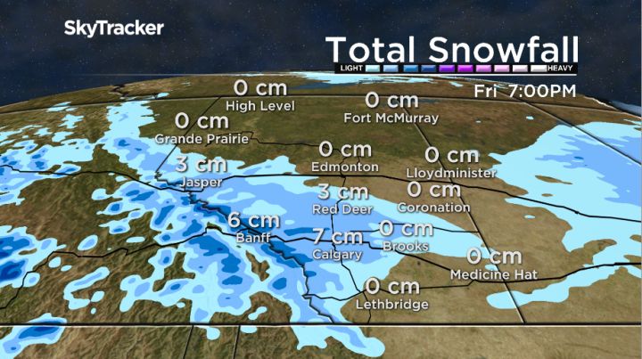
Some forecasting models are suggesting as much as 10 centimetres of snow is possible for parts of Alberta Friday.

An arctic high pressure system bringing freezing temperatures into the province is expected to meet up with moisture coming from the west coast. As the two systems collide, the result could bring freezing rain for some areas and snow in others.
Calgary could see between six and 10 centimetres of snow by supper Friday, with a daytime high of only 2ºC. That is 12 degrees below the seasonal average daytime high of 14ºC.
That arctic high is likely to stick around for a while, keeping temperatures well below average.
According to Global Calgary forecaster Paul Dunphy, Calgary will likely only reach single-digit daytime highs until next Thursday.
It is not unusual to see snow in Calgary this time of year. According to Environment Canada’s Canadian Climate Normals from 1981 – 2010, the average snowfall in September is just under four centimetres and October will see an average of 10 centimetres of snow.


Calgary’s first official snowfall in the latter half of 2015 occurred Sept. 5 and 6 when there was a trace amount of snow both days. The first snowfall in October 2015 was on the third day of the month with three centimetres recorded.
Dunphy expects the first flakes to show up early in the morning Friday and says the snow could continue until the supper hour.
As of 6:30 p.m. Thursday, there were no weather alerts or warnings issued from Environment Canada anywhere in Alberta.
Want your weather on the go? Download Global News’ Skytracker weather app for iPhone, iPad and Android.
Comments