

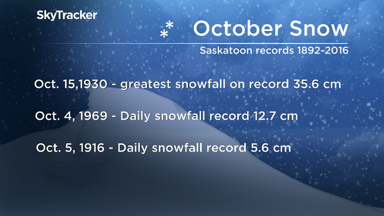
The 100-year-old snowfall record for Oct. 5 has been shattered (sort of) in Saskatoon after 7 to 11 centimetres fell on the city overnight.

The previous record dated back exactly 100 years to 1916 when 5.6 centimetres fell.
However because Environment Canada stopped measuring snowfall in Saskatoon in 2007, the record cannot officially be broken.
WATCH BELOW: Schools closed, harvest halted devastating farmers

A snowfall warning continues for Saskatoon on Wednesday afternoon after the city woke up to a winter wonderland.
With full foliage still on trees, the weight of snow on trees is causing many branches to bend and even snap, causing a number of significant power outages in the city Wednesday.
10 to 15 centimetres of snow is expected to fall in the area under a snowfall warning with upwards of 30 centimetres possible in northern parts of Saskatchewan including La Ronge.
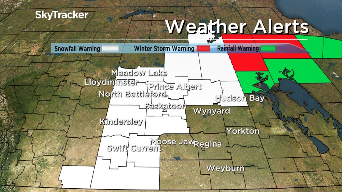
Accompanying the snow is strong wind gusts upwards of 60 km/h, at times reducing visibility.
Travel is not recommended on a number of area roads, as reported by the Highway Hotline.
Saskatoon Forecast
Today
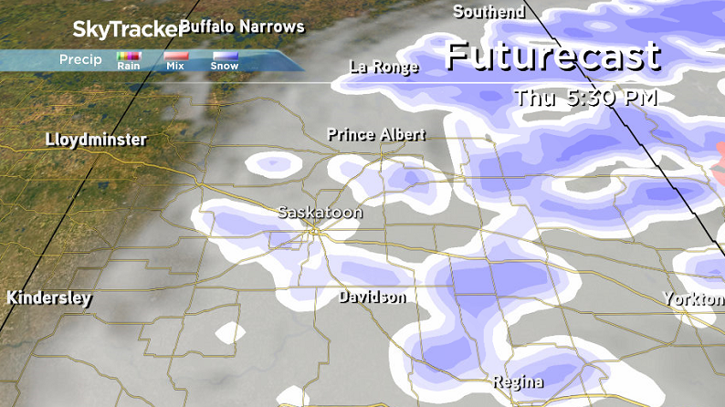
Steady snow will continue for the rest of the day with another five to 10 centimetres possible as temperatures hover around the freezing mark.
It will remain slick and breezy outside, so be sure to give yourself extra time to get to where you need to go.
Sustained wind speeds will sit around 30 km/h with gusts upwards of 50 km/h reducing visibility and making travel treacherous.
Tonight
Snow will continue tonight with a few more centimetres expected as temperatures dip back below freezing by up to a few degrees.
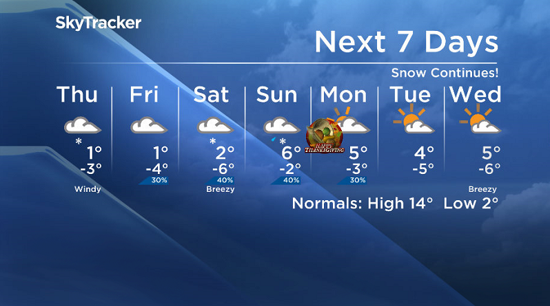
Thursday
We’ll wake up to snow on the ground again on Thursday with wind chill values making it feel around -6 or -7 when you head out the door in the morning.


Cloud cover and some light snow is expected at times during the day with winds easing back to around 20 gusting to 40 km/h from the north-northwest.
During the day we should see the mercury recover up to and possibly a degree above the freezing mark.
Snow should ease off heading into the evening as the low pressure system responsible for this snowfall pulls off further east.
Friday
Friday looks like it will remain cloudy with a slight chance of flurries and temperatures starting out below freezing before recovering up just above the freezing mark for an afternoon high.
Thanksgiving Long Weekend
- Life in the forest: How Stanley Park’s longest resident survived a changing landscape
- ‘Love at first sight’: Snow leopard at Toronto Zoo pregnant for 1st time
- Buzz kill? Gen Z less interested in coffee than older Canadians, survey shows
- Carbon rebate labelling in bank deposits fuelling confusion, minister says
There still is a level of uncertainty to the Thanksgiving long weekend forecast, particularly in the temperature department, but it looks as though cloud cover will be sticking around for the majority of the weekend.
A low pressure system passing by south of the city could pick up some precipitation likely as snow on Saturday and possibly rain or snow on Sunday as it swings by with mostly cloudy skies and a slight chance of flurries possible for Thanksgiving Day Monday.
At this point, daytime highs look to sit just above freezing on Saturday before bouncing up into mid-single digits for Sunday and Monday with overnight lows in minus single digits across the board.
We’ll keep a close eye on the long weekend outlook and bring you the latest information as soon as possible.
This Your Saskatchewan photo of the NESSAC cross country race near Star City on Tuesday, Oct. 4 was taken by Lyle Cowell:

Saskatoon weather outlook is your one stop shop for all things weather for Saskatoon, central and northern Saskatchewan with a comprehensive look at your local forecast that you can only find here.
Comments