

From Vancouver Island to the Rocky Mountains, Environment Canada has issued a variety of weather warnings for southern British Columbia.

Starting west and moving east, the national weather agency is forecasting rain, heavy at times, for most of Vancouver Island, barring Victoria and the northern end.
The western side of the island will see 100 to 125 mm rain, along with winds of 70 to 90 km/h. For the eastern half, 50-90 mm are projected, plus winds of 50-70 km/h. The downpour is expected to ease by the afternoon as the system moves east.
Read more: Ferry cancellations, highway headaches as snow and ice hit B.C. Interior, Vancouver Island
For Metro Vancouver, a rainfall warning for 25-50 mm is in effect, with 90 mm projected for the North Shore mountains.
Environment Canada says localized flooding is possible due to the ground still being frozen. The heavy rain should end by the afternoon or early evening as it moves east.
One website that tracks atmospheric rivers is forecasting Level 1 and Level 2 ratings for Vancouver Island and the South Coast.
Freezing levels are expected to climb to around 2,000 metres for Christmas and Boxing Day, and there could be significant snowmelt in low- and mid-level local mountains.
A Level 1 rating is described as being primarily beneficial, while Level 2 is mostly beneficial but also hazardous.
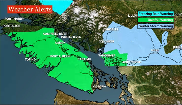
A graphic showing rainfall, freezing rain and winter storm warnings for parts of B.C., on Saturday morning, Dec. 24, 2022.

Get daily National news
For Howe Sound, the Sea to Sky Highway and Whistler, a winter storm warning is in effect, with 30-50 cm of snow in the forecast.
“A moist Pacific frontal system is giving heavy freezing rain near Squamish and heavy snow to Sea-to-Sky Highway and Whistler,” said Environment Canada. “The freezing rain near Squamish is forecast to change over to heavy rain this morning.”
The rain will end by Saturday evening as the system moves out of the region.
“Consider postponing non-essential travel until conditions improve,” said Environment Canada. “Surfaces such as highways, roads, walkways and parking lots may become icy and slippery. Ice build-up may cause tree branches to break.”

Continuing east, winter storm warnings have been issued for the Fraser Valley, the Fraser Canyon and Similkameen regions plus the Coquihalla Highway (Hope to Merritt) and Highway 3 (Hope to Princeton).


For the Fraser Valley, freezing rain at times heavy will gradually transition to heavy rain as temperatures rise above freezing,.
The transition will occur Saturday morning in Abbotsford and Mission, near noon in Chilliwack, and very late this afternoon or early evening in Hope.
Rainfall amounts of 40-50 mm are projected, with most of it occurring as freezing rain over eastern sections of the valley.
Snowfall accumulations of 10-30 cm are projected for highway passes, and 10-15 cm for the Fraser Canyon and Similkameen regions.
“The precipitation will ease by midnight (Saturday) before another system arrives early Sunday,” said Environment Canada. “This second system will give a mix of snow, rain, and risk of freezing rain. This will continue to make travel challenging on Christmas Day.”
For the Southern Interior, snowfall warnings of 10-15 cm are in effect for the North Okanagan, Shuswap, Arrow Lakes, East Columbia, Yellowhead and Elk Valley regions.
The snow is expected to end by the evening.

However, for the Boundary, West Columbia, North Columbia, West Kootenay, and Kootenay Lake, winter storm warnings are in effect, with 20-30 cm of snow projected.
Elsewhere in B.C., the North Coast is under a winter storm warning, with 25-50 cm of snow projected, along with freezing rain near Kitimat and Terrace. Wind chill values will also be near -20.
A freezing rain warning has also been issued for inland sections of the Central Coast.
More information is available online at Environment Canada.
Comments
Want to discuss? Please read our Commenting Policy first.