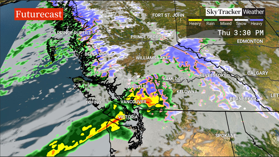
Environment Canada has issued multiple rainfall and wind warnings, as the season’s first atmospheric river bears down on British Columbia’s coast.

The storm system is forecast to hit the north and central coasts first, with heavy rain anticipated Wednesday through Thursday morning, before moving on to Metro Vancouver through Thursday.

Haida Gwaii, and the North and Central Coast could see between 50 and 100 mm of rain over a 24 hour period. Strong winds of 90 km/h gusting to 110 km/h are also forecast for the inland Central Coast, according to the warnings.
On Thursday, when the storm hits the South Coast, Howe Sound and Metro Vancouver’s North Shore and northeast, including Coquitlam and Maple Ridge are forecast to see up to 50 mm of rain.
“The more concerning part of this system, the cold front, will hit the South Coast on Thursday,” Global BC senior meteorologist Kristi Gordon said.

“This cold front is concerning because it’s not like most cold fronts. It is what meteorologists call an Atmospheric River — it is very long and is transporting a massive amount of water vapor from the tropics across the Pacific. It looks like a river in the sky or a fire hose of water aiming right for the B.C. coast.”
Gordon said the system was classified as AR1, meaning it is moving down the coast quickly, and not expected to dump heavy rain over any particular area for more than a day.

Get daily National news
“By comparison, in fall of 2021 this region experience three back to back atmospheric rivers which stalled over the region for many days. These were classified as AR 2-5 and brought 174 mm of rain to the community of Hope in just one day.”

- Old Man Winter wallops B.C.’s Mainland/Southwest region, major highway closed
- Calgary hit by unexpected blast of spring snow, causing dozens of crashes
- False spring strikes again: Saskatchewan prepares for incoming winter weather
- Albertans’ interest in alternative forms of travel growing as fuel prices spike
The South Coast, including eastern Vancouver Island and the Sunshine Coast is also projected to be battered by winds of 50 km/h, gusting to 70 km/h near the Georgia Strait.
The heaviest rain and strongest winds are forecast to taper off Thursday evening.
Drivers are being reminded to watch for flash flooding or pooling on roads, turn their lights on, slow down and drive defensively.
Earlier Wednesday, BC Hydro said it was preparing for the season’s first storm, which comes on the heels of an unusually long fall drought.
“Now we have two years of dried-up soil and an unprecedented amount of dead and weakened trees that could pose a problem for our infrastructure,” BC Hydro spokesperson Susie Rieder said.
The Crown corporation is advising people to ensure they have an emergency kit ready, as it prepares for potential power outages.
On Tuesday, Emergency Management BC also issued a bulletin advising people to be prepared for storm season.
Atmospheric rivers are a common meteorological phenomenon that involve long, narrow bands of moisture in the atmosphere that carry water vapour from the tropics to other regions, and deposit it as heavy rainfall.
While the incoming atmospheric river is not forecast to manifest as an extreme weather event, the weather systems have drawn increased scrutiny from B.C. emergency officials and meteorologists in the wake of the catastrophic floods and mudslides triggered by a series of such systems last November.
— With files from Darrian Matassa-Fung.


Comments
Want to discuss? Please read our Commenting Policy first.