


B.C.’s South Coast is hunkering down for another 24 hours of wild winter weather, with snow, wind and rain in the forecast.

Here’s what you need to know about what’s to come, broken down by region.
READ MORE: Power outages, traffic and transit delays as new round of snow and wind hits Lower Mainland
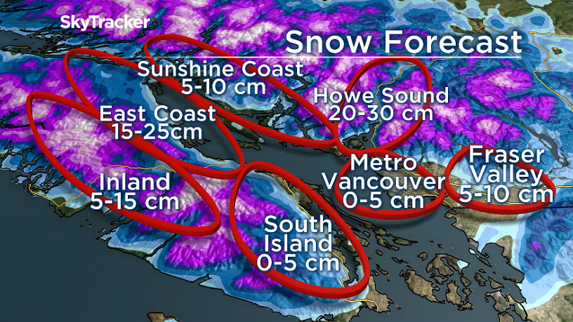
Metro Vancouver
Overnight: A chance of moderate to heavy flurries. These pockets of snow could bring up to five centimetres of snow in a very localized area. Winds will ease but blowing snow and reduced visibility still could be an issue at times.
Tomorrow: Temperatures could warm to 2-3 degrees Celsius in some areas by morning, but then drop again in the afternoon to near freezing. A chance of showers or flurries will continue through the day. The morning commute could still be rough with snow or slush still in many areas.

Fraser Valley

Get breaking National news
Overnight: Snow and winds will ease. Temperatures will warm to about -1 degrees by morning, but wind chill could remain near -10 degrees.
Tomorrow: Periods of snow will redevelop in the morning, but it looks like it could be after the morning commute. Either way, best bet is to bank on the morning commute being rough with at least icy conditions. Five to 10 centimetres of snow is possible through the day. Staying below freezing all day.

Howe Sound
Overnight: Blizzard conditions overnight with 90-110 km/h winds out on the water, 40-60 km/h winds for Squamish. Another 15 centimetres of snow is possible.
Tomorrow: Blizzard-like conditions will ease in the morning as the winds die down. Periods of snow still expected with another five centimetres possible. Staying below freezing during the day.


Victoria
Overnight: Showers. Temperature is already at 2 degrees.
Tomorrow: A chance of showers or wet flurries and a few sunny breaks. Temperatures will be around 5 degrees in the morning but the airmass could cool again in the afternoon, thus the chance of wet flurries. No accumulations expected.

Vancouver Island North & Sunshine Coast
Overnight: Snow, heavy at times, with 15 to 25 centimetres possible for parts of the island and five to 10 centimetres for the Sunshine Coast. Winds will continue overnight in the 30-50 k/h range, so blowing snow and whiteout conditions a concern. Temperature will warm by morning, especially for areas near the water.
Tomorrow: A chance of showers or flurries and a few sunny breaks. Temperatures will be around 4 degrees in the morning but will likely cool to about 1 degree in the afternoon.

Comments
Want to discuss? Please read our Commenting Policy first.