

Parts of B.C.’s South Coast are set to receive another round of snow Thursday night, with forecasters predicting even more is around the corner.

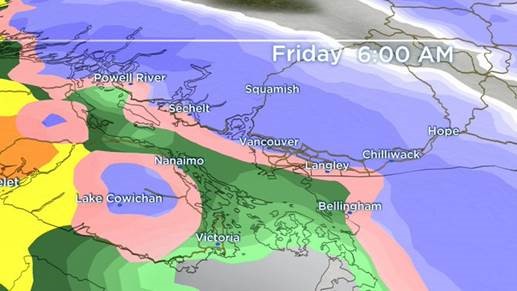
Environment Canada says there is a chance accumulations could exceed five centimetres in the Fraser Valley and higher elevations of Metro Vancouver and Vancouver Island.
The special weather statement is also in place for the Sunshine Coast and eastern Vancouver Island communities, including Nanaimo and Campbell River.
The weather agency says the snow has the potential to last into the Friday morning commute as temperatures hover around the freezing mark.
There is a chance lower elevations could also see snow or wet snow during the same period, Environment Canada says, but snowfall amounts will vary depending on the area.
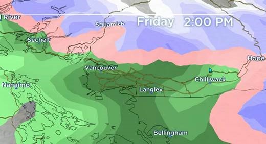
The snow and wet snow will transition to rain later Friday morning, the agency says.
Global BC senior meteorologist Kristi Gordon said the weather will make the morning commute “rather tricky,” adding the forecast has been difficult to determine.

Get breaking National news
“Due to the nature of coastal region with varying topography and temperatures hovering around the freezing mark, localized snowfall amounts are incredibly difficult to predict,” Gordon said.
“We sometimes see some neighbourhoods with no accumulations at all, while other neighbourhoods receive five to 15 centimetres in these types of scenarios.”


As for the coming weekend, Environment Canada says it’s also difficult to say what could happen next.
“There is considerable uncertainty for the weekend, but overall, a threat of more snow showers at higher levels and in the Fraser Valley will hold,” forecasters said in the special weather statement.
By late Sunday and into next week, the agency says, arctic air could bring temperatures in Metro Vancouver as low as -10 degrees Celsius by Tuesday morning.
The arctic air could also bring more snow along with wind chill across the coast.
The latest blast of winter weather comes after days of unyielding storm conditions throughout the province, which have knocked out power and created dangerous driving conditions.
You can follow the latest weather warnings from Environment Canada here.

Comments
Want to discuss? Please read our Commenting Policy first.