

A dumping of snow is expected for much of southern Manitoba on Wednesday and into Thursday.

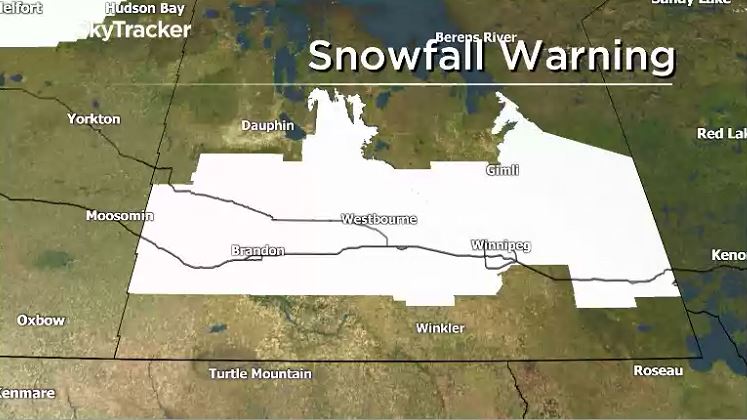
Environment Canada issued a snowfall warning for areas spanning from Virden across the Trans-Canada Highway to the Ontario border.
Ten to 15 cm of snow are expected to fall in western parts of the province late Wednesday morning, according to the federal weather agency. Winnipeggers can expect the snow to start falling later Wednesday.
The following areas are under the warning:

Get daily National news
- Bissett – Victoria Beach – Nopiming Provincial Park – Pine Falls
- Brandon – Neepawa – Carberry – Treherne
- City of Winnipeg
- Dugald – Beausejour – Grand Beach
- Minnedosa – Riding Mountain National Park
- Portage la Prairie – Headingley – Brunkild – Carman
- Selkirk – Gimli – Stonewall – Woodlands
- Ste. Rose – McCreary – Alonsa – Gladstone
- Virden – Souris
- Whiteshell – Lac du Bonnet – Pinawa
Communities along the Trans-Canada Highway are expected to be the hardest hit. Blowing snow will also reduce visibility.
The wind is expected to pick up, blowing with gusts up to 60 km/h, said Russo, so “there will be lots of blowing snow as well.” This will be a factor Wednesday afternoon in western Manitoba and later in the afternoon and evening around the Red River Valley.
Areas along the U.S. border from Melita to Piney are not part of the warning but can still expect to see just under 10 cm of snow.
However, the snow may be less than expected, he added.
“There’s a lot of discrepancies amongst the models right now,” said Russo.


“The European model… actually has the amount much less, and actually has the area shifted off to the southeast. So there is a possibility that we could escape the brunt of it.”
Another factor influencing snowfall totals will be the snow to liquid ratio. A “standard” snow to liquid ratio is 10:1 (1 cm of snow for every 1 mm of water) however with this system the ratio is more likely to be 20:1 or 25:1 meaning there could be twice as much snow build up with the expected precipitation.
Not all weather models take this into account in the same way, so a prediction of 6 cm would end up as 12 cm with the higher liquid to snow ratio.
The system is expected to taper off late Wednesday in the west and early Thursday morning in the east. As the snow leaves, much cooler temperatures are expected on Friday and much more of the same next week.

Comments
Want to discuss? Please read our Commenting Policy first.