
New data has revealed the scale and scope of this spring’s devastating floods.

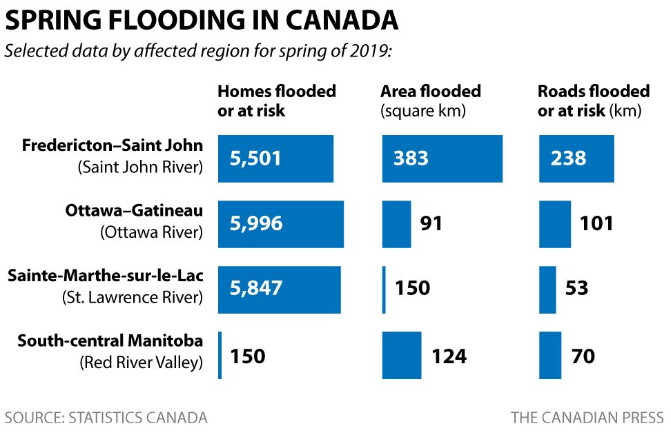
Statistics Canada says about 17,500 homes were either hit by flooding or deemed at risk — a number that could rise higher as insurance claims come in.
READ MORE: Quebec floods: army will stay to help with cleanup operations
The data also suggests some 460 kilometres of roadways were either washed out or cut off by rising rivers.
WATCH BELOW: Should old Quebec dam be torn down after flood scare?

Using satellite data from the Canadian Space Agency and Natural Resources Canada, the agency created maps that show more than 600 square kilometres of flooded land in Manitoba, New Brunswick and Quebec.
READ MORE: Quebec government gives green light to rebuild dike in Sainte-Marthe-sur-le-Lac
That includes some 153 square kilometres of agricultural zone land, which could have a direct impact on the 2019 growing season.
Some municipalities were harder hit than others this spring — particularly in Quebec and New Brunswick.
WATCH BELOW: Volunteers step up to help flood victims

In Quebec, Pontiac and Sainte-Marthe-sur-le-Lac, communities northwest of Montreal, saw 29 and 25 per cent of homes either hit by flooding or deemed at risk.
READ MORE: Improving flood mapping is first step in future mitigation, expert says
The New Brunswick communities of Lincoln and Burton as well as Pointe-Calumet, northwest of Montreal, rounded out the top five, with between 15 to 16 per cent of homes in those communities either flooded or at risk.
WATCH BELOW: Does Quebec need better flood maps?

Comments