

Environment Canada issued a number of special weather statements and warnings on Sunday for southern Alberta — including Calgary.

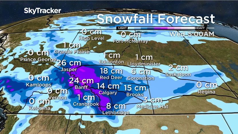
The national weather agency warned that some areas closer to the foothills could see as much as 20 cm of snow by Wednesday. Most forecast models suggest Calgary is likely to receive between five and 10 cm of snow.
A low pressure system is expected to move from British Columbia on Monday, bringing snow into Alberta Monday night and lasting until Wednesday.
According to the statement, snowfall totals will likely be the heaviest from Nordegg to Pincher Creek with some higher elevations seeing more than 20 cm. That system is expected to track east and could bring up to 10 cm to areas east of the snow line, although forecast totals could change within the next 24 hours.

Get daily National news
Meteorologists from Environment Canada said the biggest concern with the incoming snow is how the system will affect highways.
“Regardless of how much snow falls, it is likely that the highways near and west of Calgary, including the Trans-Canada, will experience poor driving conditions on Monday night and Tuesday,” the weather alert read.
Banff National Park was placed under a snowfall warning Sunday due to “a long period of snowfall with total amounts of 10 to 20 cm expected.”


The heaviest snow is expected to fall Monday, first around the Icefields Parkway before spreading south and east.
“By the time snow tapers off late Tuesday, 15 to 30 cm of new snow is expected,” Environment Canada warned.
This wintry weather is coming on the tail end of unseasonably cold temperatures in the region, with daytime highs for the end of September nearly 16 degrees colder than they should be. Calgary’s average daytime highs for the month were between 15 C to 20 C.
According to Environment Canada’s historical data, this September has had more single-digit daytime highs than any other year on record, with the coldest day peaking at 0 C — the unofficial high for Sept. 30.
The daytime highs associated with this system will likely be below freezing.
Calgary averages about 10 cm of snow in October. The first significant snow event last winter began Oct. 31.
To see the latest weather watches and warnings, click here.
Want your weather on the go? Download Global News’ Skytracker weather app for IOS and Android.
Comments
Want to discuss? Please read our Commenting Policy first.