

The BC Wildfire Service is encouraging boaters on Okanagan Lake to give helicopters and skimmers space as they scoop up water to fight the 32-hectare Glenfir Road fire near Naramata.

Fire information officer Noelle Kekula said it is dangerous and hazardous to boaters and wildfire crews when boaters get too close to the fire suppression operations.
“Boats were interfering not only with our helicopter bucketing operations but the skimmers yesterday,” she said.
“Late in the afternoon we had the skimmers out on the lake again and RCMP had to manage the boats to ensure that we could continue with our fire suppression efforts and that there wasn’t an incident.”
Kekula said RCMP boats were circling the area on Saturday to advise boaters of the precautions that should be taken.
“The pilot determines their flight path to get to the lake to get the water and if all of a sudden a boat interferes in their flight plan that could cause a real issue, there could be a collision,” she said.
WATCH BELOW: Fire boss bullish on battle against Okanagan wildfires, concerned for firefighter fatigue in heat

-
![]() Fire boss bullish on battle against Okanagan wildfires, concerned for firefighter fatigue in heat
Fire boss bullish on battle against Okanagan wildfires, concerned for firefighter fatigue in heat -
![]() Crews making progress against Okanagan wildfires
Crews making progress against Okanagan wildfires -
![]() Local businesses affected by Okanagan wildfires
Local businesses affected by Okanagan wildfires -
![]() Air quality advisory issued due to Okanagan wildfires
Air quality advisory issued due to Okanagan wildfires -
![]() New evacuation centres open up in Okanagan following wildfires
New evacuation centres open up in Okanagan following wildfires -
![]() Police link nearly 30 arson wildfires in the Okanagan
Police link nearly 30 arson wildfires in the Okanagan


When asked if the boat operators were oblivious to the dangers or intentionally getting close to watch the fire suppression efforts, Kekula said she didn’t know.

Get daily National news
“It’s fun to watch that, it’s so interesting but please do it from a distance,” she said.
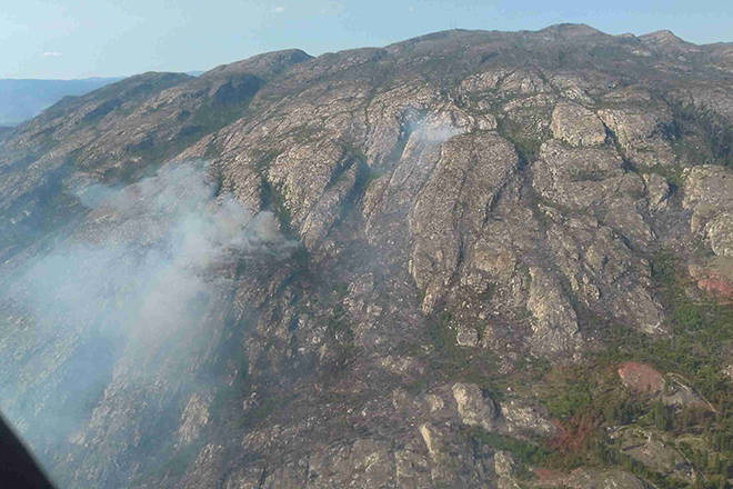
The Glenfir Road fire 10 kilometres northwest of Naramata, which ignited on July 17, is still classified as out of control.
The BC Wildfire Service says 30 firefighters, assisted by air support, are battling the fire by extinguishing hot spots and initiating a final patrol of the bottom half of the fire to detect and smother any remaining heat.
READ MORE: Heat warning issued across Okanagan Valley
“The fire over the last week has been creeping north into the park and we are, with the steep cliffs, crews continue to try to build a type of containment using water on the north flank because of the rock,” Kekula said.
Intense heat is posing a challenge for ground crews. Kekula said don’t be surprised to see firefighters jump into the lake to reduce their body heat.
“Fire season is really starting to perk up across the province and we need to make sure their health is still intact for when they go on to their next incident,” she said.
While the 32-hectare blaze is classified as an interface fire, no homes are threatened at this time.
OKANAGAN wildfires
Peachland Creek
- Location: 2.5 kilometres west of Peachland.
- Size: 23 hectares.
- Cause: Lightning.
- Status: Classified as being held.
Goode’s Creek
- Location: 21 kilometres south of Kelowna, in Okanagan Mountain Provincial Park.
- Size: 1,370 hectares.
- Cause: Lightning.
- Status: Classified as out of control. Fifty-four personnel on site with air support as needed.
- BCWS notes: “Crews will continue to focus their suppression efforts on the south flank by extinguishing any heat they find while patrolling. The north flank will begin to undergo a demobilization of equipment.”
Mount Eneas
- Location: Four kilometres south of Peachland, immediately west of Highway 97.
- Size: 1,793 hectares.
- Cause: Lightning.
- Status: Classified as being under control. Eighty-seven personnel on site and two pieces of heavy equipment.
- BCWS notes: “With the sustained heat, some green patches are drying out and re-igniting which is putting up lots of smoke. This is completely contained and within the blackline. Crews are aware and monitoring.”
Frederick Creek
- Location: Okanagan Mountain Provincial Park.
- Size: 56.5 hectares.
- Status: Never listed as a ‘fire of note’ by the BCWS.
Glenfir Road
- Location: 10 kilometres northwest of Naramata.
- Size: 32 hectares.
- Cause: Lightning.
- Status: Classified as out of control. Forty-four personnel on site with air support as needed. The Naramata Fire Department is on night shift.
- BCWS notes: “Crews will continue extinguishing hot spots while advancing into the black. In addition, firefighters will initiate a final patrol at the bottom half of this fire in order to detect and smother any remaining heat.”
Mount Conkle
- Location: Approximately eight kilometres southwest of Summerland.
- Size: 118 hectares.
- Cause: Lightning.
- Status: Classified as being held. Was removed as a ‘fire of note’ on July 27.
SIMILKAMEEN wildfires
Snowy Mountain
- Location: Remote, 14 kilometres south of Keremeos.
- Size: 1,530 hectares.
- Cause: Lightning.
- Status: Classified as out of control, with zero per cent containment. Zero firefighters. The fire is burning at a high elevation and is visible to the communities of Keremeos and Cawston.
- BCWS notes: “Daily fire growth is occurring but, within the expected Protected Area zone. This fire is located in the Snowy Protected Area. B.C. Parks has closed the Ewart and Wall Creek Trails pending further assessment of this fire. Go to B.C. Parks for updates about road or trail closures. The fire is being monitored due to the extremely remote and inaccessible location. A remote camera has been set up and is providing real time images. Plans are in place to take action on the fire should it travel outside the protected area.”
Placer Mountain
- Location: 37 kilometres south of Princeton.
- Size: 828 hectares.
- Cause: Lightning.
- Status: Classified as out of control, with zero per cent containment. Ninety-eight firefighters with eight helicopters and 12 pieces of heavy equipment.
- BCWS notes: “Continuing with mop-up on north flank progressing eastward. Continuing with burning out green islands. Additional hose line is being established from the gully on the fire’s north flank to the mine site. A spot fire is being actioned within an old burn area. A fuel free line is being constructed off the Ashnola River up the road line. A second fuel free line from North Durusseau Road is being constructed to a scree slope off Ashnola Road. Hot spots are being worked within a regeneration area. Structural protection assessments are being carried out on identified structures within the vicinity of the fire.”
Comments
Want to discuss? Please read our Commenting Policy first.