
Slow, but steady, progress is being made against the six wildfires still burning or smouldering in the Okanagan.

In the Similkameen, though, there are two massive wildfires that are nowhere close to being out.
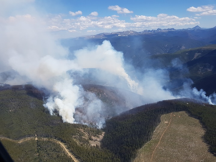
No less than 98 firefighters are involved in the Mount Placer fire, located south of Princeton. The blaze is estimated at 828 hectares and, according to the B.C. Wildfire Service, has zero per cent containment and has grown in size.
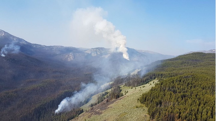
Yet it’s not the biggest fire in the region. The Snowy Mountain fire is 1,530 hectares in size and also has zero per cent containment. The fire is located 14 kilometres south of Keremeos.
Those fires are in contrast to the six in the Okanagan, which, for the most part, are either under control or are needing less firefighters to battle them.
“As some of the other fire situations have come down in intensity, we’re putting more resources onto the (Mount Placer) fire,” said B.C. Wildfire Service information officer Ken Juvik. “Today, we have 98 firefighters out there, eight helicopters, seven pieces of heavy equipment and five water tenders.
Juvik noted there was a planned ignition on Mount Placer, a small, successful fire that burned approximately five hectares to prevent the bigger fire from spreading over the Ashnola River into Cathedral Park.

Get daily National news
Juvik also said there is an area restriction order that comes into effect at noon. He said anyone travelling Ashnola Road, at approximately 29 kilometres, will be advised not to travel into the area due to activity with firefighters, helicopters and so on.
“We certainly don’t want (the fire) heading into Cathedral Park. We’re taking all the measures necessary to ensure that doesn’t happen. But we are concerned that, depending on the weather conditions, these can change at anytime. So we’re keeping our eyes open for that.”
There is also an evacuation alert for Cathedral Park Lodge and any of the access areas associated with it.


Regarding the Snowy Mountain fire, “it hasn’t changed for several days,” said Juvik. “The fire remains up in the sub-alpine and alpine areas. We were bucketing with one helicopter yesterday and the day before just to cool some of the hot spots so it wouldn’t spread into adjacent drainages.
“But we’ve discontinued that now; the fire is just remaining steady.”
Juvik noted that BCWS has a real-time camera set up that helps monitor the fire, along with periodic fly-overs, and that plans are in place to battle the blaze if it starts encroaching on buildings.
OKANAGAN wildfires
Peachland Creek
- Location: 2.5 kilometres west of Peachland.
- Size: 23 hectares
- Cause: Lightning.
- Status: Classified as being held.
Goode’s Creek
- Location: 21 kilometres south of Kelowna, in Okanagan Mountain Provincial Park.
- Size: 577 hectares.
- Cause: Lightning.
- Status: Classified as out of control. Fifty-four personnel on site with air support as needed.
- BCWS notes: “Crews will continue to focus their suppression efforts on the south flank by extinguishing any heat they find while patrolling. The north flank will begin to undergo a demobilization of equipment.”
Mount Eneas
Location: Four kilometres south of Peachland, immediately west of Highway 97.
- Size: 1,793 hectares.
- Cause: Lightning.
- Status: Classified as being held. Eighty-seven personnel on site and two pieces of heavy equipment.
- BCWS notes: “There is a heat scan scheduled for this fire. Once the results have been evaluated, crews will respond accordingly to extinguish whatever heat is detected. In the meantime, crews will continue patrolling to seek out any hot spots. The Ministry of Transportation and Infrastructure contractors will be danger tree assessing and falling along the Highway 97 corridor between Peachland and Summerland.”
Frederick Creek
- Location: Okanagan Mountain Provincial Park.
- Size: 56.5 hectares.
- Status: Never listed as a ‘fire of note’ by the BCWS.
Glenfir Road
- Location: 10 kilometres northwest of Naramata.
- Size: 32 hectares.
- Cause: Lightning.
- Status: Classified as out of control. Forty-four personnel on site with air support as needed. The Naramata Fire Department is on night shift.
- BCWS notes: “Crews will continue extinguishing hot spots while advancing into the black. In addition, firefighters will initiate a final patrol at the bottom half of this fire in order to detect and smother any remaining heat.”
Mount Conkle
- Location: Approximately six kilometres southwest of Summerland.
- Size: 118 hectares.
- Cause: Lightning.
- Status: Classified as being held. Was removed as a ‘fire of note’ on July 27.
SIMILKAMEEN wildfires
Snowy Mountain
- Location: Remote, 14 kilometres south of Keremeos.
- Size: 1,530 hectares.
- Cause: Lightning.
- Status: Classified as out of control, with zero per cent containment. Zero firefighters. The fire is burning at a high elevation and is visible to the communities of Keremeos and Cawston.
- BCWS notes: “Daily fire growth is occurring but, within the expected Protected Area zone. This fire is located in the Snowy Protected Area. B.C. Parks has closed the Ewart and Wall Creek Trails pending further assessment of this fire. Go to B.C. Parks for updates about road or trail closures. The fire is being monitored due to the extremely remote and inaccessible location. A remote camera has been set up and is providing real time images. Plans are in place to take action on the fire should it travel outside the protected area.”
Placer Mountain
- Location: 37 kilometres south of Princeton.
- Size: 828 hectares.
- Cause: Lightning.
- Status: Classified as out of control, with zero per cent containment. Ninety-eight firefighters with seven helicopters and 12 pieces of heavy equipment.
- BCWS notes: “Crews are clearing road access with heavy equipment heading to the gully on the eastern sector of the fire and continuing to establish wet-lines. Crews will remove green islands of unburned fuels as necessary and additional firefighters will then mop-up. Heavy equipment will be used to establish a fuel free line from Ashnola to McBride Creek scree slope (a slope covered with small loose rock). Using tenders (large water hauling trucks), crews will mop-up along the top treeline/regeneration area.”
Comments
Want to discuss? Please read our Commenting Policy first.