

An intense, fast moving low pressure system and strong cold front swept across Saskatchewan on Tuesday night, bringing damaging wind gusts across the province.

The highest gust recorded was 131 km/h at Moose Jaw around 10 p.m. – a new record for the month of October – beating out the old record of 119 km/h set on Oct. 16, 1991.
WATCH BELOW: 2 towns saved, but 1 life and at least 14 homes lost during fires in Tuesday night’s wind storm


READ MORE: Wildfire threat contained in western Saskatchewan

Get daily National news
Hurricane force winds of over 118 km/h were also reported in Regina with a gust clocked at 120 km/h shortly after 10 p.m.
Saskatoon reported a gust of 113 km/h and Swift Current reached 124 km/h.
READ MORE: Major wind storm hits Saskatoon
Moose Jaw was reported as the windiest place on earth Tuesday night, followed by Regina, Saskatoon and Swift Current.
Winds remain high across most of the province Wednesday morning but will gradually diminish throughout the day.
There were some power outages in Saskatoon, however no major damage was reported.
Saskatoon Forecast
Wednesday
After a wild and windy night in Saskatoon, gusts finally dropped back out of the 100 km/h range into the 90 km/h range into the early morning hours as we fell back to 3 degrees to start the day.
Winds sat around 50 to 60 km/h with gusts upwards of 70 to 80 km/h right through the morning under pure blue skies and sunshine.
Sunny skies stuck around for the rest of the day with winds easing back to 40 km/h and gusts upwards of 50 to 60 km/h as the pressure gradient between systems started to slacken and we warm into low double digits.
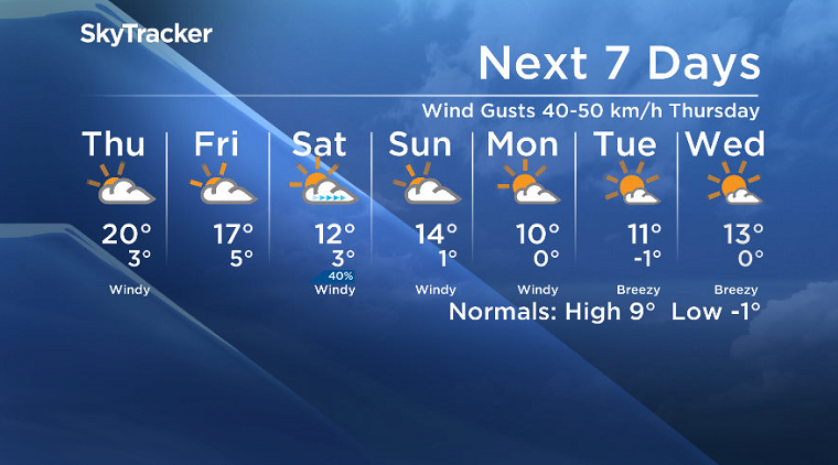
Thursday
As the next large system slides onto the coast and an upper ridge builds back in, a warm southwesterly wind around 30 km/h with gusts upwards of 40 to 50 km/h will kick in on Thursday.
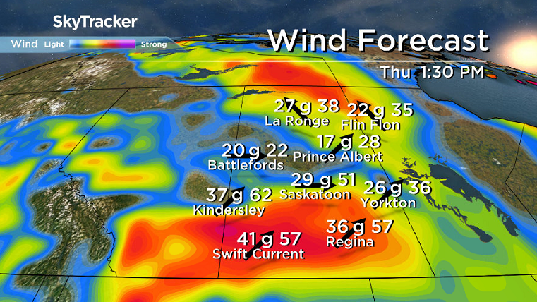
The mild weather should spring temperatures up into the upper teens or low 20s for an afternoon high under predominantly cloudy skies during the day.
Friday
We’ll finally get a break from the winds on Friday, but partly to mostly cloudy skies are expected during the day.
The upper ridge should hang on to finish off the week and keep our daytime in the upper teens.
Weekend Outlook
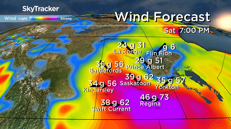
Cooler air will slide in for the weekend as an upper trough dives in, dipping daytime highs back into low-to-mid double digits and bringing back windier conditions with gusts upwards of 50 to 60 km/h under partly to mostly cloudy skies.
This Your Saskatchewan photo for Oct. 18 was taken by Joe Cortes in Saskatoon:

Saskatoon weather outlook is your source for Saskatoon’s most accurate forecast and is your one stop shop for all things weather for central and northern Saskatchewan with comprehensive, in depth analysis that you can only find here.
Comments
Want to discuss? Please read our Commenting Policy first.