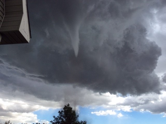
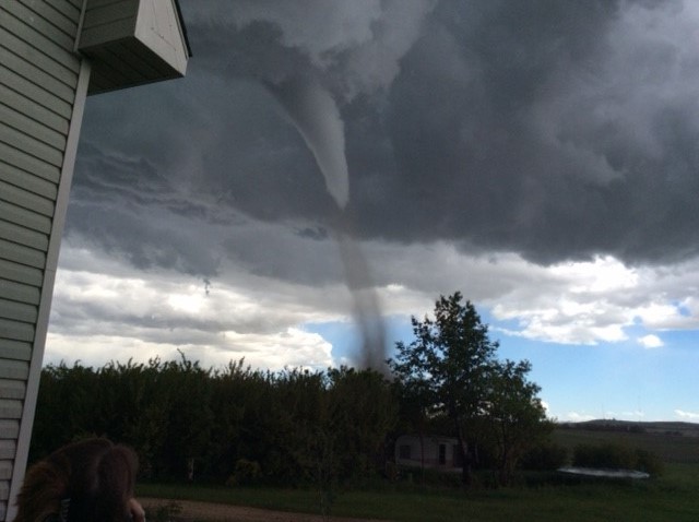
UPDATE: June 5, 2017: On Monday afternoon, Environment Canada adjusted its rating of the tornado from an EF-0 to an EF-1 on the Enhanced Fujita scale, which ranges from the weakest (EF-0) to the strongest (EF-5). On Friday, the weather agency said the twister generated wind speeds of up to 130 km/h and that the only damage it had received reports of was a shed roof that was destroyed. On Monday, Environment Canada said the twister had generated wind speeds of up to 175 km/h and that the tornado threw an “anchored empty grain bin” 400 metres, shifted a semi-filled grain bin, destroyed an RV and snapped some trees in addition to damaging the roof of a barn.

A tornado touched down in central Alberta late Friday afternoon, however, no injuries were reported and there was initially only minimal reports of damage.
“It appears it was probably 15 to 20 minutes,” Environment Canada meteorologist Dave Carlsen said when asked how long the twister touched down for.
“We saw a storm pop up south of Red Deer near Highway 2 near Innisfail and it was just moving southeast and then it latched onto this boundary and it spun up and became a supercell.
“A supercell is a rotating thunderstorm and that’s the kind of thunderstorm that generally tends to produce the stronger tornadoes and that’s what we saw today.”

WATCH ABOVE: A tornado touches down north of Three Hills and damages two rural properties. As Tony Tighe reports, thankfully there were no injuries.
A tornado warning issued for areas near Trochu and Huxley in central Alberta Friday afternoon was dropped by Environment Canada at around 5:30 p.m. but not before many Albertans captured video and images of funnel clouds in the Three Hills area.
The tornado warning came into effect shortly after severe thunderstorm warnings had been issued in other parts of the region. Carlsen said photos and reports sent in by weather “spotters” prompted the tornado warning.
“The doppler radar just lit up with rotation and the signature – we call it a hook echo – which is a very telltale sign that there is likely a tornado happening – as soon as we saw that, we issued the tornado warning.”

Get breaking National news
Photos of funnel clouds were posted on social media before the weather agency issued the tornado warning just after 5 p.m.
Watch below: A viewer spotted a funnel cloud near Three Hills, Alta. on Friday evening.

Environment Canada said “storm spotters have reported a funnel cloud with this storm” as its meteorologists were tracking a severe thunderstorm “capable of producing very strong wind gusts, up to nickel size hail and heavy rain.
At around 5 p.m., the weather agency said it was tracking a fast-moving thunderstorm near Wimborne.
“This thunderstorm has produced a tornado in the past near Wimborne,” Environment Canada said on its website at around 5:30 p.m.
“The tornado has since lifted and the threat of a future tornado is no longer imminent.”
Watch below: Environment Canada issued a tornado warning for Drumheller, Three Hills. That warning has since been lifted.

On Friday night, Environment Canada said it had given the tornado a preliminary rating of EF-0 on the Enhanced Fujita scale which ranges from the weakest (EF-0) to the strongest (EF-5). The weather agency said the twister had wind speeds of up to 130 km/h and called on the public to submit photos of the tornado or damage it may have caused.
Anyone with information on the tornado is asked to call Environment Canada at 1-800-239-0484 or to email them at storm@ec.gc.ca.
Joanne Olson captured video footage of the funnel cloud while she was very close to it in the north end of Three Hills, Alta. The woman – from Stony Plain, Alta. – said she and her husband had just arrived into town for a weekend family reunion when they unpacked their bags at a friend’s house and saw the rotating cloud.
“We looked out the window and here’s this funnel coming… it looked like it was coming almost right at us,” she said, adding she was not actually afraid.
“As you watched it, it just kept coming down and then that’s when I said to Joanne, ‘grab your tablet, let’s go out and film this,’ her husband Al said. “And then it just kept coming down, down… by the time went out back, it had already hit the field and it was sucking the dirt straight up.”
The Olsons’ said despite living in Alberta for many years, it was the first time they had ever seen a funnel cloud.
“It got really black. Like after the (unconfirmed) tornado… it was completely black,” Joanne said.
Global News spoke to Deb Tucker over the phone as she was north of Three Hills shortly after she said she spotted a funnel cloud as she was driving east out of Torrington.
“What I’m seeing is – you can actually see the dust that’s come up,” she said. “It’s actually connected to the cloud that’s come out of the sky.
“We can see the rotation, it looks like it had gotten fairly sizeable.”
“It’s bouncing up and down and came down pretty far one time,” Adam Hickey – who said he saw a funnel cloud – told Global News over the phone Friday afternoon. “It looks like it’s out near Three Hills area.”


Comments
Want to discuss? Please read our Commenting Policy first.