

Spring officially arrived on Tuesday, but the Toronto area and parts of southern Ontario could get their “most significant snowfall so far this season” starting Friday, Global News meteorologist Ross Hull says.

A wave of moisture over the Prairies and another moving in from Texas, bringing some moisture from the Gulf of Mexico, will come together near the Great Lakes, dumping snowfall on the region, Hull said.
“With the GTHA and other parts of southern Ontario in line for 5-10 cm, this highlights just how little snow there has been so far this past winter,” Hull said.
At Toronto Pearson Airport, the most significant daily snowfall this season so far was on Feb. 15 when just 6.4 cm fell. On Jan. 11 and 12, there was a combined 7.6 cm.
As for the upcoming system, flurries and light snow could begin as early as Friday morning for the Greater Toronto-Hamilton Area, with light snow continuing into the afternoon, Hull said.
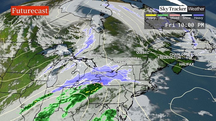
But the heaviest snowfall won’t happen until evening, likely most intense after sunset, though timing is still a bit uncertain, Hull said.

Get breaking National news
“With the higher sun angle during the day in late-March there’s a better chance of seeing snowfall accumulate at night and it does look like this system will be getting most intense at that point,” he said.
Much of the GTHA and areas stretching east towards Kingston are expected to see 5 to 10 cm from Friday evening into Saturday morning.
For London and southwestern Ontario, 4 to 8 cm is expected.


“There’s the possibility of heavier amounts of snow for the west end of Lake Ontario due to lake enhancement – higher terrain around Hamilton, Grimsby, Milton, even western parts of the GTA have the possibility of reaching past 10 cm,” Hull said.

“Breezy east winds will also pick up as the system moves in, which will likely reduce visibility under the heaviest snow bands. Important to mention that there is still uncertainty on the exact track of this storm, so changes to this forecast are still possible.”
Hull said the system will quickly move out Saturday morning.
“With sunshine over the weekend and that high late-March sun angle, we don’t expect the snow to stick around very long, but people will have some time to enjoy the fresh snowfall early Saturday at least,” he said.
Comments
Want to discuss? Please read our Commenting Policy first.