


With wildfires raging in the Maritimes, Alberta and B.C.’s northeast, ongoing dry conditions on the province’s South Coast are now raising concerns.

Crews with the BC Wildfire Service are already battling the 160-hectare, out-of-control Newcastle Creek wildfire near Sayward on Vancouver Island.
There have already been 45 fires so far in the Coastal Fire centre — dozens more than the six recorded at this point in the admittedly damp 2022 season — but still about 60 per cent above the 10-year average, according to the wildfire service.

“We still have to wait and see what rain comes in June,” fire information officer Julia Caranci said in an interview.
“May and June rains are generally a fairly good indicator of what kind of fire season we are going to have.”

Get breaking National news
In comparison with that cool and damp May last year that essentially delayed the start of summer, this year has been virtually drought-like.
According to Environment Canada, the province’s South Coast has received just 15 to 20 millimetres of precipitation throughout the month.
Environment Canada meteorologist Matt Loney said 2023 has been the driest May in the last decade for some parts of the province.
“That’s only about 20-30 per cent of the normal we would expect for the month, so we are running quite a bit of a precipitation deficit on top of an already dry spring,” he said.
“We’ve already got dry subsoils, dry soils, and on top of that we are expecting warmer than normal temperatures for next week.”


While traditional weather patterns on the South Coast have often earned June the nickname of “Juneuary,” Loney cautioned this year could buck the trend.
Early modelling with a “medium” confidence level suggests the low-pressure systems that often sit over the South Coast during the month could instead stay over the Pacific Ocean, with a high-pressure ridge from central Canada poking over the Rockies, and bringing dry summer weather with it, he said.
The more solid forecast for the next week, he said, suggests “pleasantly warm” weather.
“If we look in our crystal ball for June, the next few days don’t really bring any relief,” Loney said.
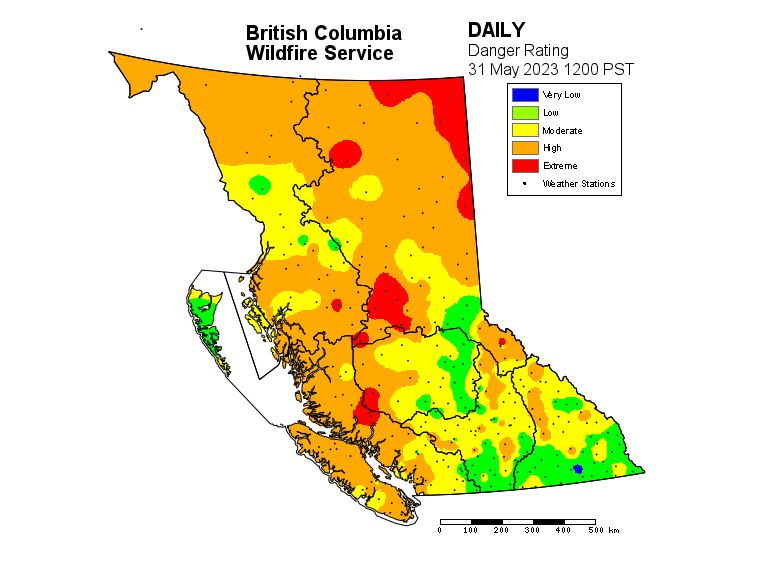
As of Wednesday, the province’s fire danger rating listed all of the South Coast at a risk rating of either “moderate” or “high.”
Metro Vancouver has also raised the fire danger rating at several regional parks to “high,” prompting a ban on charcoal briquette barbeques and restrictions on other cooking stoves in some areas.
Comments
Want to discuss? Please read our Commenting Policy first.