

Much of southern Ontario is set to see plenty of rain starting on Friday, with some areas expected to receive a month’s worth over just a few days, Global News meteorologist Anthony Farnell says.

“It’s been a wet spring so far across southern Ontario and we will be adding to those totals in the next week,” he said.
“A large blocking high across northern Quebec and Labrador is acting as a road block and stalling weather systems as they move across the Great Lakes.”
Farnell said the next round of wet weather moves in on Friday, with 15 to 25 mm expected by Saturday afternoon, but “that’s just the beginning.”
“A deep trough will remain in place through the middle of next week, keeping the weather chilly and unsettled,” he said.
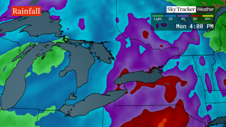
Late Sunday and into Monday, heavy rain is expected, more so for eastern Ontario and southern Quebec.

Get daily National news
Farnell noted that those areas are already dealing with very high water levels and some flooding.
While forecast details can still change, it’s likely that some areas will see up to 60 mm of rain in the next week, which is a month’s worth, Farnell said.
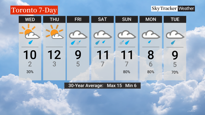
It means that overall, the cloudy conditions and rainfall will “all but guarantee” temperatures will be below seasonal through the first week of May.
But there may be light at the end of the tunnel.
- Old Man Winter wallops B.C.’s Mainland/Southwest region, major highway closed
- Calgary hit by unexpected blast of spring snow, causing dozens of crashes
- False spring strikes again: Saskatchewan prepares for incoming winter weather
- Albertans’ interest in alternative forms of travel growing as fuel prices spike


“There is some hope that this pattern changes after that, and we may be dealing with another warm up that will have us feeling like it’s suddenly summer by the second week of May,” Farnell said.


Comments
Want to discuss? Please read our Commenting Policy first.