

It is going to get cold in B.C. this week.

Global BC meteorologist Mark Madryga said colder air is racing southwards down the province with a gusty “north-to-northwest wind in most places, generating a biting wind chill.
“Some snow is also falling, which will be blowing and drifting especially on the highways (Tuesday) through Wednesday,” he added.
Affected routes include the Coquihalla Highway (winter storm warning), Highway 3 (winter storm warning and snowfall warning) and the Trans-Canada Highway (winter storm warning).
For the Coquihalla Highway, a winter storm warning is in effect between Hope and Merritt.

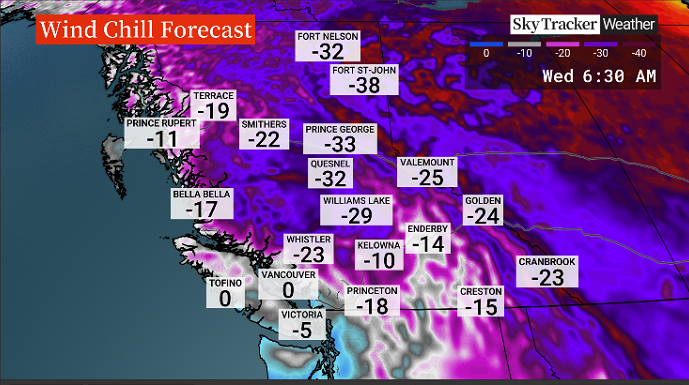
Wind chill values of -30 C or colder will be common in the central and northern parts of the province for the next couple of mornings, Madryga said.
On the South Coast, Arctic air is scheduled to sweep out from the Interior Tuesday evening, with chilly, gusty outflow winds and some snow showers accompanying the Arctic front Tuesday.

Get daily National news
“Further flurries are destined to fall on Wednesday on the South Coast, with accumulations of snow likely, especially on south and east Vancouver Island,” Madryga added.
- Old Man Winter wallops B.C.’s Mainland/Southwest region, major highway closed
- Calgary hit by unexpected blast of spring snow, causing dozens of crashes
- False spring strikes again: Saskatchewan prepares for incoming winter weather
- Albertans’ interest in alternative forms of travel growing as fuel prices spike


The weather will be dry and very cold for this time of year into Saturday.


Madryga said South Coast residents can then expect a more widespread snowfall Saturday afternoon and evening.
— with files from Doyle Potenteau
Comments
Want to discuss? Please read our Commenting Policy first.