

Residents of B.C.’s South Coast should brace for a severe winter storm that will bring hazardous conditions, Environment Canada said Thursday.

Travel conditions will be challenging due to heavy snow, ice pellets, freezing rain and then heavy rain on snow or ice.
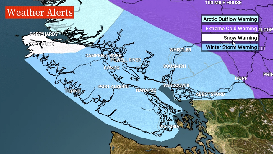
Environment Canada issued the winter storm watch on Wednesday and upgraded it to a warning Thursday.
Starting Thursday evening, residents of the South Coast and Vancouver Island can expect heavy snow followed by freezing rain and rain, localized strong winds, and a localized windchill of -25 due to arctic outflow winds, and then localized flooding in heavy rain.
Freezing rain is expected during the transition from snow to rain, which could cause significant impacts on road conditions.

Winter storm warnings are now in effect for east Vancouver Island, the Fraser Valley, Greater Victoria, the Malahat between Goldstream and Mill Bay, Howe Sound, the Sea to Sky region from Squamish to Whistler, inland Vancouver Island, Metro Vancouver, the southern Gulf Islands, the Sunshine Coast, west Vancouver Island and Whistler.
Mainroad Contracting, which is responsible for clearing some of the roads and highways, said there “is a very high probability that all roadways in the Lower Mainland will become snow-covered this evening, then ice-covered throughout the day on Friday.”
In a statement, the company said travel conditions will be treacherous and highway closures are likely to occur.
Mainroad is advising the public not to use the roadways on Friday unless for emergency reasons.

B.C.’s Minister of Transportation and Infrastructure Rob Fleming strongly advised people against any unnecessary travel between Thursday evening and Saturday.
“In the interest of safety, we may need to close highways at a moment’s notice,” he said.
Fleming said all maintenance contractors have been working long hours this week to try and keep roads clear and are prepared for heavy snow to hit the region beginning Thursday night.

Get breaking National news
He added they are watching the freezing rain “very closely” and this will be the biggest concern.

Fleming said the highways that could be hit hardest will likely be the Malahat Highway and Highway 4 through Port Alberni on Vancouver Island.
On the mainland, the Coquihalla Highway, Highway 1 through the Fraser Canyon and Highway 3 are the biggest concerns.
As freezing levels rise, heavy snow will become mixed with ice pellets and then change to rain late Friday over most of Vancouver Island, and Friday night to Saturday over the mainland, according to Environment Canada.
Snowfall amounts of 10 to 20 centimetres are expected. Local blowing snow is possible in strong easterly winds resulting in near-zero visibility.

Read more: Moderate to strong atmospheric rivers expected for B.C.’s west coast: River Forecast Centre
Environment Canada meteorologist, Bobby Sekhon, said the freezing rain event, especially in the Fraser Valley, could be as short as 12 hours or as long as 36 hours so it’s important to be prepared for the worst-case scenario.
The public should keep an eye on weather forecasts and alerts, he said.
As the system progresses and warming becomes dominant, heavy rain is expected.
That could bring localized flooding due to snow-blocked drains and melting snow.

Cancellations and closures


BC Ferries is warning there may be delays and cancellations due to the weather.
The Vancouver Park Board has also closed the Stanley Park Seawall between Third Beach and the Lion’s Gate Bridge.
Kwantlen Polytechnic University said it was closing all campuses at 8 p.m. Thursday, and that they would remain closed Friday.
Simon Fraser University also said all of its campuses would be closed Friday. UBC has yet to make an announcement about operations on Friday.
Science World in Vancouver also announced it would be closed Friday.
Global BC meteorologist Mark Madryga said frigid air resides over all of Western Canada, with sub-zero temperatures across B.C. again Thursday.
Close to three dozen daily record low temperatures were set on Wednesday, including Vancouver at -12.9 C, Chilliwack at -14.5 C (where records go back 141 years), Kamloops at -26.6 C and Dawson Creek and Fort St John at -42.5 C, Madryga added.

“Again, many temperature records go back over a century at a large number of weather stations,” he said.
In addition, numerous records were broken Thursday morning, including Vancouver Airport at -13 C for the second consecutive morning.

Bowinn Ma, Minister of Emergency Management and Climate Readiness said warming centres are open in many communities across B.C.
If anyone is in need of a warming centre they should check with their local community.
“These are very dangerous conditions and we want to make sure everyone is safe,” Ma said.
She warned that power outages are also possible, especially on Vancouver Island and in the Fraser Valley.
Ma urged everyone that if they absolutely have to travel, to pack a winter survival kit including water, non-perishable food, blankets, batteries and flashlights.
Comments
Want to discuss? Please read our Commenting Policy first.