A combination of a healthy snowpack and anticipated cooler weather suggests British Columbia is at a “slightly elevated” risk of flooding from spring runoff, according to the B.C. River Forecast Centre.

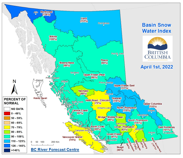
The April Snow Survey and Water Supply Bulletin, published Friday, found snowpack levels ranging from 74 to 134 per cent of normal in varying regions, averaging out to 99 per cent provincewide.
“The combination of near-normal April 1st snowpack, La Niña conditions forecast to persist through spring, recent snow accumulation during the first week of April, and seasonal weather forecasts that predict cooler conditions for the province means a slightly elevated risk for freshet-related flooding,” the bulletin says.

“Snowpack is only one factor related to freshet flood risk. Weather conditions from April through June determine the timing, magnitude, and rate of snowmelt, and heavy rainfall events can exacerbate the situation.”
The River Forecast Centre noted that rivers affected by the devastating November 2021 floods could be at higher flood risk during the spring freshet, but that, fortunately, snowpack levels in the Nicola, Similkameen and Lower Fraser regions were not above normal.

The survey found snowpack levels in the Nicola (69 per cent), Chilcotin (72 per cent), Okanagan (74 per cent) and Vancouver Island (74 per cent) regions to be notably below average.

Get breaking National news
The Northwest (134 per cent), North Thompson (119 per cent), Upper Fraser east (117 per cent) and Upper Columbia (115 per cent) regions showed above-average snow accumulation.
The bulletin cites a 53 per cent chance of a La Niña climatic system, which historically brings cooler and wetter weather, to persist through the summer, which could result in late-season snow accumulation or delayed snowmelt, increasing flood risk.
“Seasonal weather forecasts from late March by Environment and Climate Change Canada indicate an increased likelihood of colder than normal temperatures from April through June for coastal and northern regions of the province, along with pockets in the South Interior,” the report notes.
Read more: B.C. to provide nearly $500,000 to help 14 communities develop emergency evacuation routes
The centre is forecasting near-normal spring runoff volumes for the Quesnel, South Thompson and Skeena regions, and slightly above normal flows for the Upper Fraser, North Thompson and Thompson River.
It says runoff in the Similkameen River and Cowichan River could be “well above normal,” with flows of up to 120 per cent of average.
The River Forecast Centre said projections for Okanagan Lake, Nicola Lake and the Nicola River and Kalmalka-Wood Lake are less certain due to an updated model for the region, but that the “well below normal” snowpack levels in the area suggest a lower risk.


Comments
Want to discuss? Please read our Commenting Policy first.