

Summer 2021 in Alberta was one for the record books.

The province battled a heat dome at the end of June, wildfire smoke throughout much of August and the quietest tornado season ever.
The fall season won’t be quite as interesting, but winter may be a different story as sea surface temperatures start to shift from an ENSO-neutral state to La Niña.
Hot and dry summer
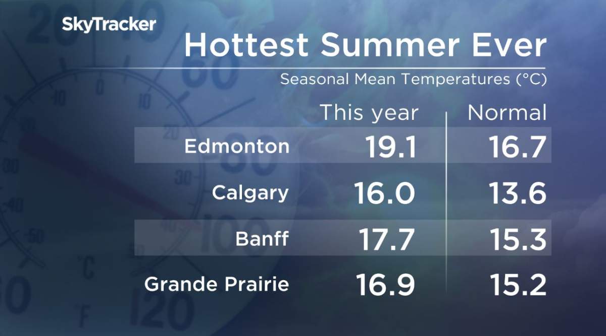
Much of Alberta had a hot and dry summer. It was the warmest season on record for Calgary, Edmonton, Banff and Grande Prairie and the second warmest for Red Deer, Fort McMurray and Lloydminster.
“In terms of daily maximum temperature records, Alberta recorded 255 in June, 110 in July, and 73 in August for a summer total of 438,” Environment Canada decision support meteorologist Justin Shelley said.
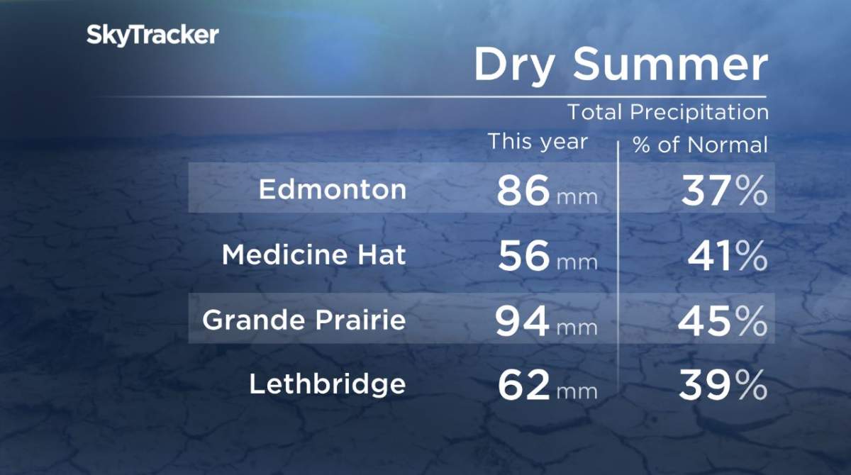
As for moisture, it was the driest summer on record for Edmonton and ranked in the top 10 driest summers for areas like Lethbridge, Medicine Hat and Grande Prairie.
Calgary also had its smokiest year on record, with 510 smoky hours recorded as of Aug. 31.
The city’s smokiest year was back in 2018, when 450 smoky hours were recorded.
Edmonton had its third smokiest year on record, with 125 smoky hours as of Aug. 31., which is still a ways away from the record of 230 hours set in 2018.
Environment and Climate Change Canada (ECCC) said a “smoky hour” is when the Calgary International Airport weather station reports visibility under 10 kilometres due to smoke and only records that data from May until September.

Get breaking National news
“Smoke hours are relatively new, since about 2016, we have started to look at data about smoke conditions to help tell the story about forest fire smoke,” Environment Canada meteorologist Alysa Pederson said.
It was also an active hail and windstorm season in Alberta: the province had 31 more hail storms and 11 more wind events than normal.
But it was a different story when looking at the number of tornadoes.
Only three tornadoes were recorded and all were ranked as EF-0 with winds between 105-137 km/h.
On June 5 there were two touchdowns, one near Longview and another near Blackie, then on June 6, another tornado touched down near Lacombe. The latter wasn’t confirmed by Environment Canada until Sept. 29.
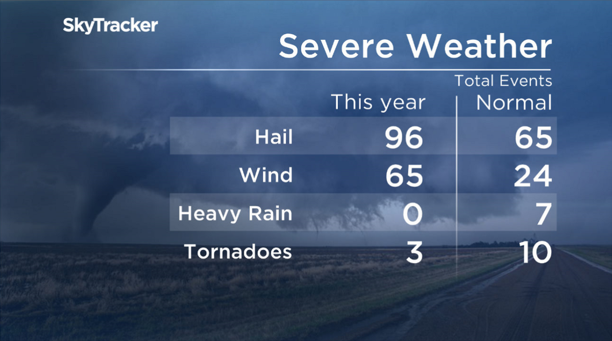
Environment Canada told Global News it was the quietest tornado season in Alberta — and the Prairies as a whole — in nearly four decades.
The weather agency also noted that investigations are still ongoing with other possible tornado touchdowns.


Fall + Winter Outlook
This year, the fall equinox lands on Sept. 22 and marks the first day of the astronomical season. However, meteorologists analyze the seasons based on annual temperature trends.
Seasonal predictions for fall encompass the months of September, October and November.
Predictions for the winter season cover the three coldest months of the year: December, January and February.
When looking at fall as a whole in Alberta, temperatures are expected to stick around the normal mark.
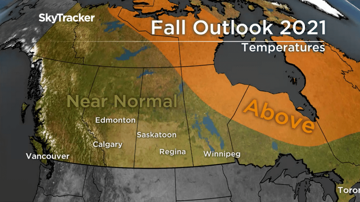
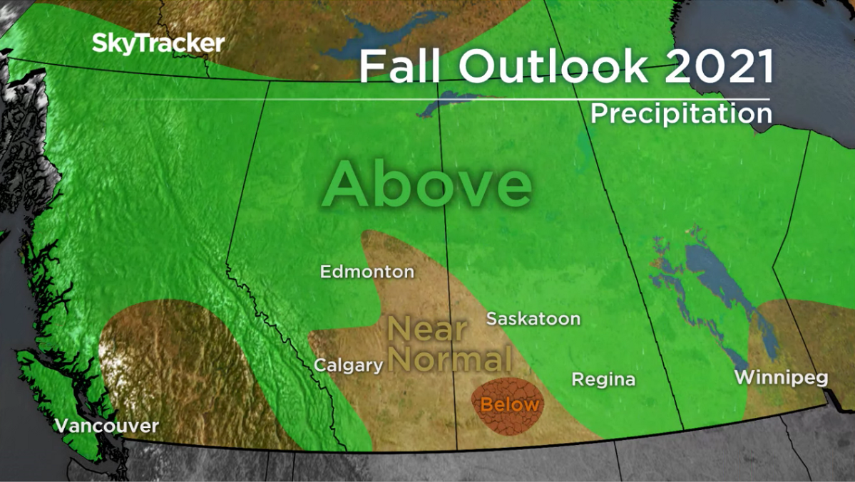
When looking at moisture predictions, the Rockies, northern and west-central Alberta could see a bit of a wetter fall than normal.
Southern and east-central Alberta will likely see near-normal amounts of rain and snowfall throughout the fall months.
Although Alberta is expecting a fairly typical fall for much of the province, winter 2021/2022 could be a bit more exciting.
Right now, equatorial sea surface temperatures are in an ENSO-neutral state across most of the Pacific Ocean, but we’ll likely see a shift to La Niña in the next couple of months.
In short, a strengthening La Niña pattern means colder and snowier conditions can be expected across the Prairies this winter season.
A La Niña pattern also dominated during winter 2020/2021.

Comments
Want to discuss? Please read our Commenting Policy first.