

It’s the end of 2020 but it’s going to be a stormy start to 2021 for B.C.

New Year’s Eve will be calm but the next storm arrives Thursday, meteorologist Yvonne Schalle said.
“It will be packing quite the punch — it’s a juicy one.”
This storm will bring lots of moisture in the form of rain and snow and will continue New Year’s Eve day and into the evening.
Metro Vancouver will receive between 15 and 25 millimetres of rain but a rainfall warning is in effect for the North Shore, including West Vancouver and the northeast, including Coquitlam and Maple Ridge.
These areas will receive between 40 and 60 millimetres of rain in 24 hours.


Over the Sunshine Coast, from Sechelt to Gibsons and the Howe Sound area, similar amounts are likely with the bulk of the rain falling during the day on Friday, Schalle added.
Localized flooding in low-lying areas is possible.
- Tornado warning downgraded as thunderstorm sweeps over Medicine Hat, southeastern Alberta
- Tornado touches down in Peace River region of northwestern Alberta
- Severe thunderstorm watch issued for Calgary, Lethbridge, Medicine Hat
- Home insurance costs soared 45% in 6 years due to extreme weather: StatCan


Get breaking National news
On Vancouver Island, even more rain is in the forecast.
Between 80 millimetres and 110 millimetres of rain is expected to fall on the west coast with strong winds expected late Thursday and continuing Friday.
A wind warning is in effect for East Vancouver Island, including Nanoose Bay to Fanny Bay and Courtenay to Campbell River.

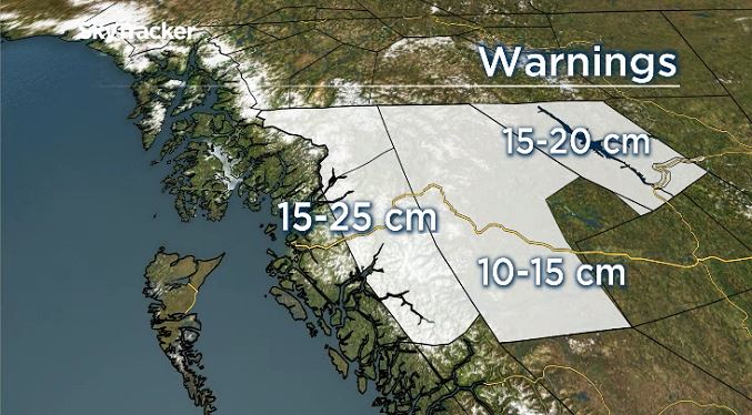
The North Coast can expect snow with a snowfall warning in effect for the area.
Snowfall amounts of 15 centimetres can be expected by Friday morning and the snow is expected to start to fall early Thursday evening.
“We are going to be under a very active pattern going into the long weekend,” Schalle said. “We have a parade of storms on deck for the start of 2021.”
Comments
Want to discuss? Please read our Commenting Policy first.