


An intense low-pressure system with subtropical moisture has prompted Environment Canada to issue a rainfall warning for much of B.C.’s South Coast, prompting a flood watch for Metro Vancouver.

The so-called atmospheric river will continue to deliver heavy rain to the region Friday, with an estimated 100 to 120 mm hitting parts of Metro Vancouver, 60 to 120 mm in the Fraser Valley, 130 mm in Howe Sound, 60 mm for Whistler, and 90 mm for Gibsons.
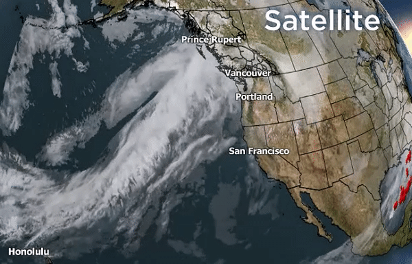
Satellite imagery shows atmospheric river flow with subtropical air emanating from near Hawaii, generating double-digit afternoon high temperatures on Friday, a freezing level above 2,000 metres, and heavy rainfall.

“The warm front associated with this system moved through the area last night bringing rain, at times heavy. For Metro Vancouver, Bowen Island and Gibsons, there will be a break this afternoon as the warm front lifts north towards Squamish,” Environment Canada said Friday.

“The cold front associated with this system will return tonight with another round of heavy rain that will last through to Saturday midday.”
Environment Canada went on to say heavy rains could lead to flash floods and water pooling on roads. Low-lying areas could see localized flooding while washouts are possible near rivers, creeks and culverts.
As of 2 p.m. Friday, Vancouver Harbour had already seen 50 millimetres of rain since Thursday afternoon, while the weather agency said the North Shore and Pitt Meadows had seen 52 and 72 millimetres of rain, respectively.
The River Forecast Centre has issued a flood watch for the North Shore and Metro Vancouver, including the Coquitlam River, Alouette River, Kanaka Creek, and MacKay Creek.
“The public is advised to stay clear of the fast-flowing rivers and potentially unstable riverbanks during the high-river-level period,” the River Forecast Centre said.
The District of North Vancouver is on flood watch Friday, asking residents to “maintain a safe distance from moving water and help clear leaves and debris from catch basins.”
Flooding was seen on Highway 10 and 177B Street in Cloverdale, with water seen gushing out of the manhole cover in the middle of the intersection amid heavy rush hour traffic.

Get daily National news
Still Creek Drive in Burnaby was partially closed due to the flooding, which also shut down nearby Westminster Avenue completely.
Port Coquitlam closed Coast Meridian Road southbound and all but one lane northbound due to flooding, as well as Kingsway Avenue at Bedford Street.
Residents in that city and others are being invited to pick up sand from public work yards to fill their own sandbags.
The heavy rains also created two mudslides to come down along the Crescent Beach bluff in the South Surrey-White Rock area, stalling freight train traffic.
BNSF Railway spokesperson Gus Melonas said crews were out clearing trees, mud and other debris from the tracks, and expected freight trains to begin moving through the area again by 8 p.m.
- Edmonton’s stormwater system strained after repeated heavy rain
- First Nations chiefs call for inquiry into Ontario wildfire response
- How the Northern Tornadoes Project helps verify twisters as Alberta on track for record year
- Inquiry hears avalanche danger moderate on day of 2021 fatal Banff snow slide


However, Amtrak passenger train service between Vancouver and Bellingham has been suspended for at least 48 hours due to the slides, with service not expected to resume until at least Sunday.
TransLink was forced to delay West Coast Express tips leaving downtown Vancouver and briefly shut down SkyTrain service in the Burnaby-Coquitlam area due to flooding.
In Maple Ridge, flooding in the area of 132 Avenue and 224 Street forced businesses to close due to rising waters that have also impacted nearby homes.
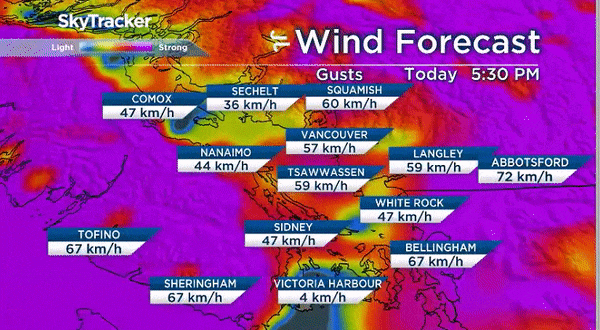
Heavy winds are also expected with southerly gusts expected to increase to 50 to 70 km/h in many areas Friday afternoon and evening. Winds are expected to move northwesterly on Saturday morning, ushering in much cooler, drier air along with rapidly falling freezing levels.
Inclement weather has led to closures of North Shore mountains. Mount Seymour said it will be closed on Friday night while Grouse Mountain said its downhill area will be closed Friday.
BC Hydro said it is working to manage water inflows into the Alouette Reservoir by doing a controlled release into the Alouette River, and is encouraging residents along the river to prepare for possible flooding.
The rainfall caps off one of the wettest Januarys in recent history.
Vancouver International Airport has seen 241 millimetres of rain and snow so far this month, the fifth most precipitation in January since 1937.
Fifty-six of the past 62 days have seen some form of precipitation, about 14 more days than average.

Comments
Want to discuss? Please read our Commenting Policy first.