

A moisture-packed Colorado low is expected to move northward and mix with cold air sinking down from the Arctic, making the perfect combination for September snow across the southern Prairies.

Snow is forecast to start on Friday afternoon and continue all weekend and into Monday.
Environment Canada says there is still uncertainty around snowfall accumulations as warm surface temperatures will melt initial snowfall.
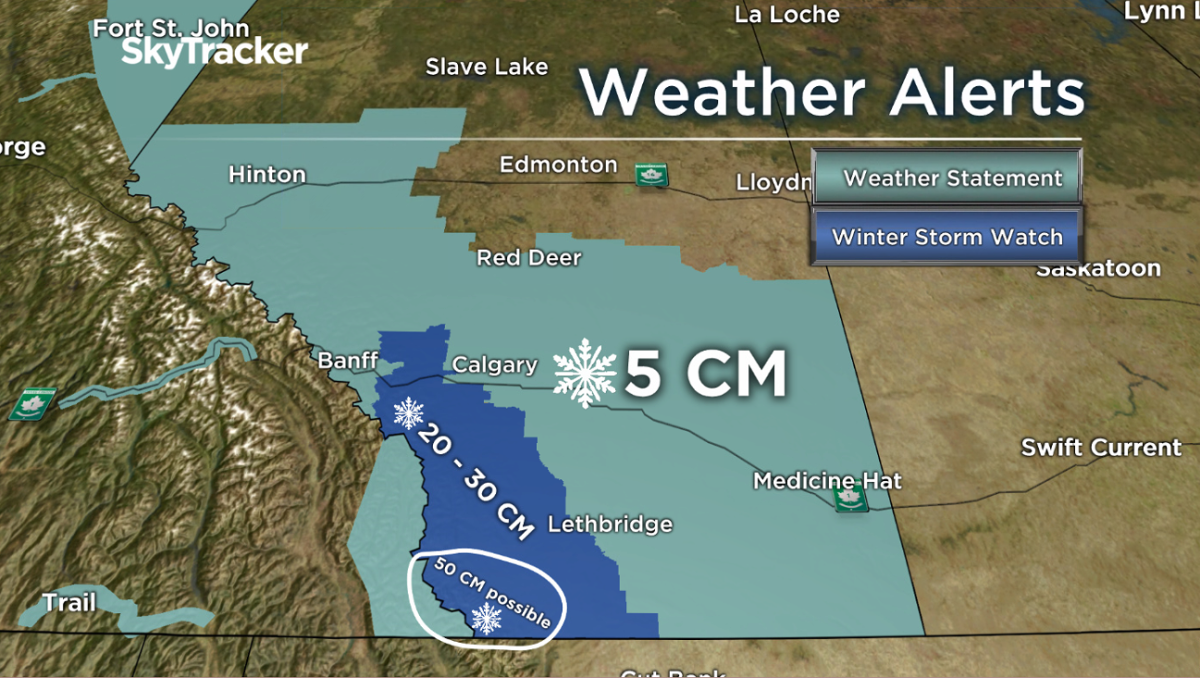
Current indications suggest that by Monday, total accumulations of 15 to 30 centimetres over portions of southwestern Alberta are possible.
Lesser amounts are forecast for Calgary and Lethbridge, with 5 centimetres possible by Sunday morning. Snow is expected to continue into Monday for parts of Alberta.
Winter storm watches, frost advisories and special weather statements stretch across the province. Visit the Environment Canada for the most recent alerts.
Scroll the images below for which regions are under weather alerts.


READ MORE: Summer 2019 in Calgary: 71 days with rain, few days above 25 C

Get daily National news
Although Calgary isn’t expecting as much of the white stuff, Calgarians are still getting ready.
Don Huber at Kal Tire said the phone has been ringing off the hook this week, and on this past Monday alone, over 200 appointments were booked for people looking to put their winter tires on.
“At the end of the day, you want to make sure you have your winter tires on because it’s a softer compound — the tires are designed to give you more traction in the snow and ice,” Hubert said.
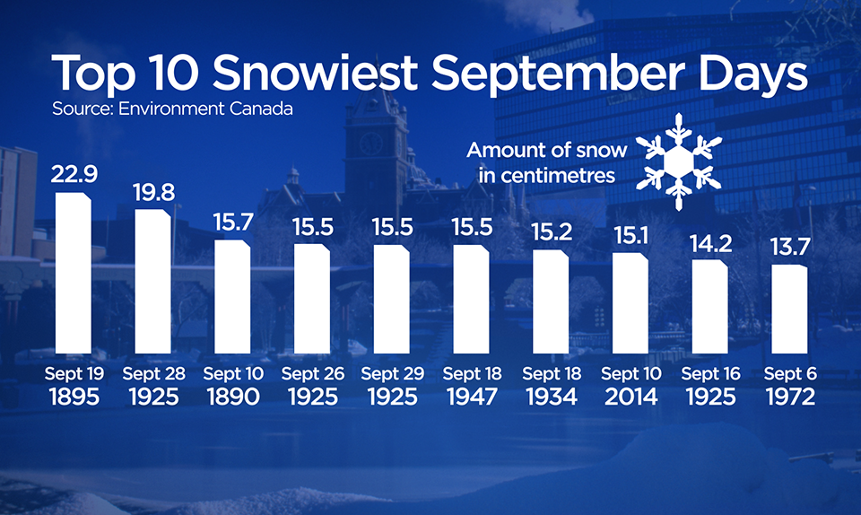
Snow in September isn’t actually all that unusual.
Snowfall totals between 13 and 23 cm have been recorded anywhere from the beginning of September to the end.
Of course last year’s snowfall during the first few days of October is top of mind, when Calgary saw over 20 cm fall in the city.
Thankfully, Calgary isn’t expecting that much snow over weekend, but areas like Pincher Creek could see double-digit accumulations.
Because the ground is still warm, the snow will melt quickly but temperatures are forecast to stay below seasonal well into next week and for the beginning of October.
City advising people to plan for conditions
- Thorhild, Westlock counties declare state of agricultural disasters due to rain
- ‘Prolonged stretch of hot air,’ poor air quality advisories blanket the Prairies
- 2 tornadoes touched down in Rocky Mountain House, Environment Canada confirms
- Heavy Nova Scotia rain threatens flooding on anniversary of deadly 2023 flash flood


WATCH ABOVE: Officials with the City of Calgary’s roads department say they are ready for the snow expected to fall the Sept. 27 weekend. Doug Vaessen has details.
The City of Calgary said Thursday it’s prepared for any snow that might move into the city over the weekend.
“We have been getting our vehicles and crews ready,” roads maintenance district manager Jim Fraser said.
“This first storm of the season will likely result in accumulation of snow on the streets, but the warm road temperatures and mild weather should make this a relatively easy cleanup for us.”
Months ahead of the winter season, city officals are organizing the snow and ice control program in hopes of being prepared for a variety of weather conditions. When inclement weather is on its way or has arrived, crews will sand, salt and plow roads according to the city-approved priority system.
“This priority system keeps the greatest number of commuters moving quickly and safely,” Fraser said.
Drivers are being reminded to prepare for the conditions, adding the first snowfall of the season “always seems to catch people a little off guard.”
“Give yourself a little bit of extra time, plan for delays, slow down and drive to the conditions,” Fraser said.
“Drivers are reminded to leave at least 10 metres distance — about three car lengths — between your vehicle and the working sanders, graders and other snow removal equipment. Do not pass working sanders or equipment,” the city said.
Information on road conditions can be found on the city’s website, Twitter account, on city traffic cameras or by contacting 311.
The city is also launching a new snow route notification system through the myID system so citizens, including those living along snow routes, can get text and e-mail notifications when parking bans are put in place.
To stay updated with radar and weather alerts in your area, download the Global News Skytracker weather app for iPhone, iPad or Android.
Comments
Want to discuss? Please read our Commenting Policy first.