
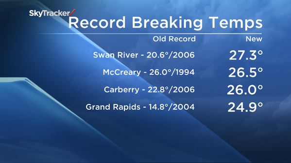
WINNIPEG – A slew of new temperature records were set Tuesday as southern Manitoba enjoyed summer-like conditions with back to back afternoons in the low to mid-20’s. Swan River came in as the hot spot in Manitoba both Monday and Tuesday with highs of 26.9 and 27.3 degrees Celsius respectively.

This warm spell comes on the heels of one of the coldest April’s in history and a chilly start to the month of May. Unfortunately, it’s not destined to last. Mother Nature’s fury brought a very powerful winter weather system to northern Manitoba, dropping 10 to 15 centimetres of snow along with visibility-reducing winds to the town of Churchill and up to 10 centimetres to other regions along the province’s northern border. And while southern Manitoba won’t see any snow, it will see conditions change for the remainder of the week as a result of that passing storm.


Get daily National news
A cold front will slice across the south Tuesday night, dropping the temperature and shifting the winds to the north. The remainder of the week will see below seasonal temperatures with a recovery towards normal on Sunday.
Comments
Want to discuss? Please read our Commenting Policy first.