

The County of Renfrew, located west of Ottawa, declared a county-wide state of emergency on Sunday afternoon as water levels along the Ottawa, Bonnechere and Madawaska rivers continue to rise and flood its communities.

Ottawa River levels in the county are currently higher than the historic peak levels seen during the 2017 floods.

“I would ask that residents continue to be diligent of the safety for themselves and those around them in these difficult times, and that residents can be assured that the County of Renfrew along with all impact municipalities in the county are making all efforts to provide support where and when needed,” Warden Jennifer Murphy said in a news release from the county.
READ MORE: Flooding persists in Eastern Canada: Here’s what’s happening in Ontario, Quebec and New Brunswick
Five municipalities within Renfrew County — Whitewater Region, Horton, McNab/Braeside, Laurentian Valley and Greater Madawaska — have already declared states of emergency in recent days. The county is also under a flood warning.
Military troops were helping with flood relief efforts in Horton on Saturday, according to an update late that same day from the Canadian Armed Forces.
READ MORE: Army on the ground in flooded Clarence-Rockland; more flood victims registering in Gatineau
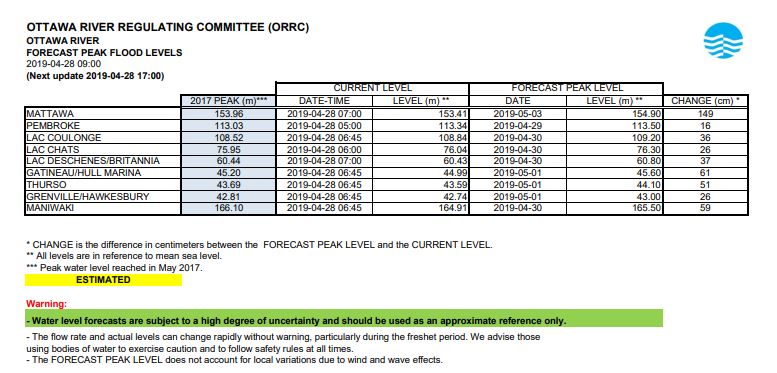
The latest forecast from the Ottawa River Regulation Planning Board on Sunday morning predicted water levels in Chats Lake, near Arnprior, will continue to rise another 26 centimetres before peaking on Tuesday.


In Pembroke, located further north upstream, water levels have also surpassed the 2017 peak in that area. They are projected to increase another 16 centimetres before peaking on Monday.
As of publication, the City of Pembroke has not declared a state of emergency.

Get breaking National news
The cities of Ottawa and Clarence-Rockland, the neighbouring Township of Alfred and Plantagenet, and three municipalities in the Outaouais are also under states of emergency due to flooding.

Comments
Want to discuss? Please read our Commenting Policy first.