UPDATE: The extreme cold warning mentioned in this story has ended

For the third straight day, Saskatchewan is under an extreme cold warning.
Environment Canada said this is due to an arctic high pressure ridge that has settled over the province.
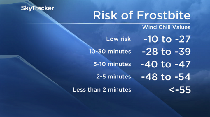
Extreme wind chill values of -40 C to -50 C continue Friday morning for most of Saskatchewan.
The very cold weather is expected to last through the weekend in most of the province and for most of next week.
School buses have been cancelled Friday in both Regina and Saskatoon due to the extreme cold.
Saskatoon smashed a 112-year record on Feb. 6 when the temperature plunged to -42.5 C. The previous record for the day was -41.7 C in 1907.

Get breaking National news
Environment Canada senior climatologist David Phillips called the record-smashing cold impressive.
“We’re talking about more than 25 degrees colder than it should have been,” Phillips said.
Phillips said the northern Saskatchewan community of Key Lake was the coldest place in Canada on Thursday morning when residents woke up to a bone-chilling -45.7 C.
February so far has been colder than normal, he said, but temperatures in December and January were a few degrees warmer than average.
As for the question of when the deep freeze will end, Phillips said highs in Regina next week are forecast to hover around -15 C.
“That 10 degrees might feel like a tropical heat wave.”
- False spring strikes again: Saskatchewan prepares for incoming winter weather
- Albertans’ interest in alternative forms of travel growing as fuel prices spike
- Massive avalanche closes Alberta’s Icefields Parkway until at least Saturday
- 13 years after Calgary’s devastating flood, 6 riverfront properties are for sale
The average high for this time of year in Saskatoon is -9 C, and in Regina -8 C.
Frostbite can occur in less than 10 minutes at these values.
Anyone heading outside should dress warmly and in layers and ensure the outer layer is wind resistant.
People working outside should take regular breaks to warm up.
Cold-related symptoms including shortness of breath, chest pain, muscle pain and weakness, numbness, and colour changes in fingers and toes.
Emergency supplies, such as extra blankets and jumper cables should be kept in vehicles.
For the latest conditions and warnings, download the SkyTracker weather app.


Comments
Want to discuss? Please read our Commenting Policy first.