As parts of Alberta deal with the first snowfall of the season, Calgary finds itself in a battle to reach seasonal temperatures.

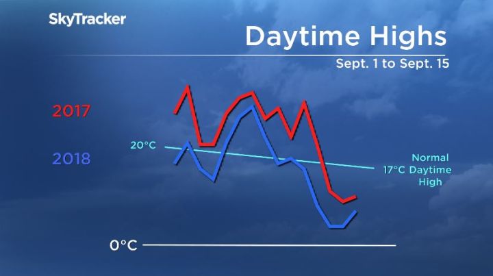
The first half of September 2018 has been considerably cooler than the same period last year. In fact, there has not been a daytime high this month that was warmer than the corresponding day in 2017.
Daytime highs in Calgary typically average between 18 C and 20 C for the first half of the month of September. This year, there will only be six days that meet or exceed that temperature. That same two-week period last year had 12 days above seasonal, with eight days above 25 C.
Mixed precipitation is expected to move into the Calgary area as early as Thursday, but the majority of it won’t likely stick to roads and sidewalks.

Get breaking National news
WATCH: Horticulturist Kath Smyth joins Global News Morning Calgary with advice on how to successfully bring your plants out from the cold to enjoy inside.

Special weather statements were issued by Environment Canada on Tuesday for areas of central Alberta warning of winter-like weather for the middle of the week.
“A cold air mass from the Northwest Territories has invaded northern Alberta and will continue to push south over the next couple of days.”
As of 1:30 p.m. Wednesday, regions closer to Jasper remain under a snowfall warning with snowfall accumulations of between 10 to 15 centimeters possible.
Forecast highs for Calgary for the end of the week are expected to be 13 C below seasonal, peaking at just 5 C. The last time Calgary had a temperature that cold this early in September was in 2014.
Want your weather on the go? Download Global News’ Skytracker weather app for IOS and Android.


Comments
Want to discuss? Please read our Commenting Policy first.