
Several fires burning around Kimberley, B.C. remain out of control Tuesday night.

“As the smoke clears today and tomorrow, more extreme fire behaviour may be observed,” the B.C. Wildfire Service said.
The town of Kimberley and properties to the south and southeast of the city remain on evacuation alert while residents from 65 properties in the area of St. Mary Lake still can’t return to home.
The fire intensity is expected to exceed the capability of ground resources on the fires, according to a the Meachen Creek Complex fire report issued on Tuesday.
“Local winds will determine the direction of fire spread,” the report said. “When the effects of slope and wind compound, moderately fast rates of spread will be experienced.”
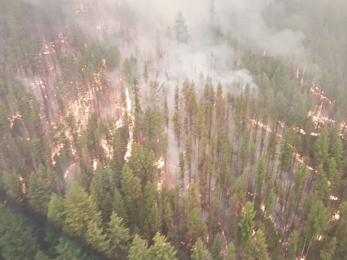
The Meachen Creek fire is estimated at 6,996 hectares and 14 firefighting personnel, three helicopters and seven pieces of heavy equipment have been assigned to the blaze located in the Kianuko Provincial Park and Meachen Creek drainage. The fire is burning about six kilometres southwest of properties under evacuation order around St. Mary Lake.

“Structural protection units will begin protecting values in zone two which is to the east of St. Mary Lake up to Lake Front Road,” the report said.
The B.C. Wildfire Service is planning a high-level scan of the Meachen Creek fire in the coming days to map the perimeter of the fire.
An incident management team from Ontario, comprised of a crew of 22 people, assumed command of the Meachen Creek Complex Sunday night.
Another 706-hectare fire burning 14 kilometres north of Kimberley, part of the Lost Dog Complex fires and is also burning out of control.
“Some hand ignitions will once again be conducted on the east flank to eliminate unburnt fuels,” the BC Wildfire Service said. “A heavy helicopter with bucket will be used to suppress the line in the uncontained area.”
The Mount Dickson fire is 1,391 hectares and is burning out of control, but not as active as other area fires, south of the Meachen Creek wildfire.
- High-profile B.C. sex offender Randall Hopley pleads guilty to 3 charges
- White Rock fatal stabbing suspect still at large while investigators remain tight-lipped
- BC Hydro offers free AC units to lower-income, vulnerable customers
- ‘It’s nice to be the villain’: Vancouver Canucks gear up for Game 3 in Nashville
“This fire is being monitored and therefore no ground resources have been assigned, only three helicopters,” the B.C. Wildfire Service said.
Fourteen wildfires in the Regional District of East Kootenay are keeping crews busy.
On Monday, the RDEK issued a regional recap:
Leach Creek (N12565) – This fire is located approximately 3km north of Mount Taylor and 21 km southeast of Sparwood. This fire remains estimated at 30 hectares in size.The fire is 95% guarded and being held, meaning that sufficient suppression action has been taken that the fire is not likely to spread beyond existing boundaries under the prevailing forecasted weather conditions.
Mt. Erickson (N12574) – This fire is lightning caused and estimated at 79 hectares. It is NE of Sparwood.
Coal Creek FSR (N12395) – This fire is located approximately 12 kilometres east of Fernie. It is currently estimated at 713 hectares and highly visible from Fernie and Alberta. This fire is currently not threatening any communities. There are currently 12 firefighters on scene. The guard has been built in priority areas. Crews have successfully reinforced guard with small scale hand ignition operations. Ground crews continue to work on containment. The Coal Creek Forest Service Road is closed beginning at the 33 km mark. The Leach Creek Forest Service Road is restricted beginning at the junction of Leach Creek Forest Service Road. The Corbin Road, and Morrisey Creek Forest Service Road are restricted beginning at the 0.3 km on Morrisey Forest Service Road, from the junction with Morrisey Road.
Cross River Fire/Nipika Mountain Resort – (N21982) – The Cross River Fire is currently estimated at 3,708 hectares. This fire size has changed due to more acurrate mapping. Resources include 17 firefighters, and 6 pieces of heavy equipment. The machine guard on the south flank of fire of the fire is now complete. Crews and heavy equipment continue to work on contingency line. Ground crews are also addressing danger trees. The evacuation ORDER for 9 properties on Settlers Road and Cross River FSR remains in place.


Sage Creek (N12024) – The fire is estimated at 1947 hectares. There is a modified response fire meaning it is managed using a combination of suppression techniques, including direct and indirect attack, and monitoring to steer, contain and otherwise manage fire activity within pre-determined perimeters. This type of response is used to minimize costs and/or damage and to maximize benefits from the fire.This wildfire is 65% contained and has not experienced any significant fire growth since August 16. Any changes in size since then have been the result of more accurate mapping. In the next 24 hours, the wildfire will remain active within its current perimeter; no growth is expected. There are currently 106 firefighters, 11 helicopters and 2 airtankers on site.It is located approximately 65km southeast of Fernie along the BC/AB border. Crew placement is challenging due to steep slopes, falling debris in burned areas, shifting winds due to mountain terrain and the inversion that is currently causing poor visibility. A number of Forest Service Road restrictions remain in place – check the BC Wildfire website for details.
Whitetail Creek (N41525) – This fire is currently estimated at 576 hectares and is located about 40km from Radium. Classified at 50% guarded and 20% contained. Management of this fire is being turned over to Parks Canada to monitor as action as required. This is a modified response fire – the fire is being managed using direct and indirect attack management tactics and fire behaviour monitoring to contain the fire within pre-determined perimeters. This type of response is used to minimize costs and damage, and to maximize ecological benefits from the fire. The resources on site include 11 firefighters and 2 pieces of heavy equipment. The wildfire does not pose a threat to the Radium Hot Springs or local communities at this time. This fire does not currently pose a risk to visitors of Kootenay National Park; however, as a precautionary measure, area closures and smoke advisories have been put into place by Parks Canada. Visit https://www.pc.gc.ca/apps/scond/Rec_Rep_E.asp?opark=100253 for more information.
Bloom/Wickman (N12515) This fire is currently estimated at 577 hectares. This fire is burning west of the community of Newgate near the US border.
Randal Creek (N72436) This fire is currently estimated at 879 hectares. Crews continue to support heavy equipment guard extending to the west to prevent spread of the fire. Crews continue to assess for potential burn off operations to be implemented when appropriate. There are currently 19 firefighters and 1 helicopter on site.An evacuation ALERT for 1 address remains in place. Neither Yahk nor Kingsgate are included in the evacuation alert.
Wardle Creek Fire – Parks Canada continues to manage the Wardle wildfire in Kootenay National Park. Significant progress has been made toward containing the fire and it is now being held. This means that the fire is not expected to spread beyond existing or predetermined boundaries, given prevailing and forecasted conditions. Highway 93S is still subject to temporary closures or reduced speeds to ensure the safety of the public. Check http://www.DriveBC.ca and http://www.511.alberta.ca for possible temporary closures, alternate routes and the most up-to-date information.
Akenside Creek Fire (N21714) No significant change to report on this fire – which remains estimated at 374 hectares.
Bull River Fire (N12407) Fire continues to be estimated at 760 hectares.
Mcdermid Creek (N12563) This fire is estimated at 70 hectares.
South Line Creek (N12685) This fire was discovered August 15 and is currently estimated to be 15 hectares.
Elk Valley (South of Mount Fernie) (12507) This fire is suspected to be lightning caused and 1.1 hectares.
Comments