
Smoke from fires burning across the B.C. Interior has reduced air quality to a moderate-to-high health risk on the air quality health index.

The Okanagan is heading into its fourth week with a special air quality statement in effect reminding people having difficulty breathing to remain indoors.
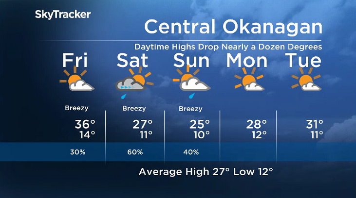
The smoke has come with a streak of mid-30 degree heat to end the week with daytime highs popping right up under a ridge of high pressure prompting Environment Canada to issue a heat warning for the area.
The smoke is trapping a lot of the sun’s energy and putting a damper on daytime heating, so what may have been upper 30 or even low 40 degree daytime highs are being knocked back sometimes more than 5 degrees.
A big change in the weather pattern is on the way, heading into the weekend, with the upper ridge of heat sliding out after one more day of mid-to-upper 30 degree heat on Friday.
Smoky skies and sunshine start off the day before clouds spring up later on with a slight chance of late day showers and the risk of a thunderstorm.

The transition really starts to take hold on Saturday, as a cold front begins to help clear out the smoke and brings in clouds, gusty winds and a good chance of showers and storms during the day after some sunshine to start the day.
Temperatures will dive back nearly a dozen degrees with afternoon highs back into the mid-20s this weekend with some lingering clouds and showers Sunday as an upper low swings in before some late day clearing.


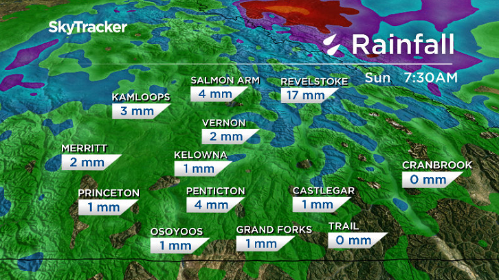
No major rain accumulations is expected, but some higher elevation areas that see storms could see upwards of 10 to 20 millimetres with 0 to 5 millimetres expected in the valley.
Warmer and sunnier days return next week with afternoon highs hopping back into the low 30s by mid-week.
For weather on the go download the Global News SkyTracker Weather App for iPhone, iPad or Android.
Comments