

For the second time in a week, a fog advisory was issued for a swath of Alberta Wednesday, while at the same time northwestern parts of the province were advised some 10 to 20 centimetres of snow could fall by the weekend.

Fog advisory
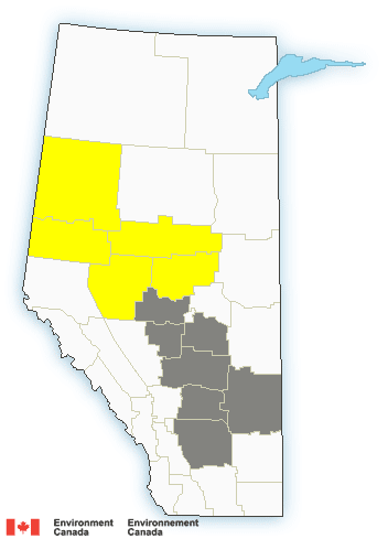
The fog advisory Wednesday morning stretches from the Peace River region in the northwest, down past the Edmonton area and through central Alberta to the Hanna and Brooks areas in south and southeastern Alberta.
Environment Canada said areas of dense fog have formed in parts of western, central and southeastern Alberta, which may cause near zero visibility at times. The fog is expected to dissipate later Wednesday morning.
Travel was expected to be hazardous due to reduced visibility.
Fog advisories are issued when near zero visibility fog is expected or occurring. Drivers are encouraged to turn on their headlights and maintain a safe following distance.
Winter storm watch

Get daily National news
Winter storm watches were also issued for north and northwest of Edmonton in the Athabasca, Grande Prairie, Peace River, Edson and Whitecourt regions.
Significant snow and strong winds giving occasional blowing snow are expected Thursday evening into Friday, Environment Canada said.
“A low-pressure system will move into central Alberta Thursday evening bringing heavy snow and strong winds to western and central parts of the province.
- Edmonton’s stormwater system strained after repeated heavy rain
- First Nations chiefs call for inquiry into Ontario wildfire response
- How the Northern Tornadoes Project helps verify twisters as Alberta on track for record year
- Inquiry hears avalanche danger moderate on day of 2021 fatal Banff snow slide


“Current indications suggest the heaviest snow will fall in an area that extends from Peace River southwards to Grande Prairie and then eastwards into the Whitecourt and Barrhead regions where 10 to 20 centimetres of snow is possible by Friday evening,” the weather agency said.
“In addition, strong easterly winds, with gusts upwards of 60 km/h, will accompany the snow giving occasional reduced visibilities in blowing snow, especially in open areas and along exposed highways. Conditions will improve Friday night as the low-pressure system moves out of the province.”
Environment Canada said it was still unclear where the low-pressure system would go, so the watches may be expanded to adjacent regions when the track becomes more clear.
One of the best ways to track locally hazardous driving conditions is from local viewer reports. The #yegtraffic hashtag is often used by Twitter users reporting traffic issues within Edmonton, and #abroads across the rest of Alberta. Global News will also publish updates to the #abstorm and #yegwx hashtags.
Want your weather on the go? Download Global News’ Skytracker weather app for iPhone, iPad and Android.
Comments
Want to discuss? Please read our Commenting Policy first.