

Nearly every single day in November was above normal for Saskatoon – but big changes are ahead!

Snowfall Warning

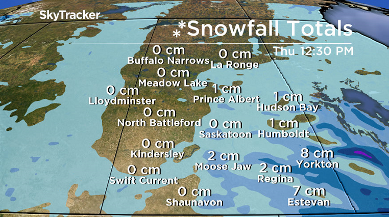
A snowfall warning remains in place in southeastern Saskatchewan including the Moosomin, Carlyle, Estevan and Weyburn areas for a prolonged snowfall event with 15 to 25 centimetres expected.
A low pressure system over North Dakota has already dumped 10 to 15 cm of snow to much of the region in the past day or so.
Snow will continue over the region into Tuesday evening, with further snowfall amounts in the five to 10 cm range.

Get daily National news
Amounts will slowly diminish overnight and Wednesday morning as the system gradually weakens.
Visibility may be reduced at times in heavy snow.
Environment Canada says to consider postponing non-essential travel until conditions improve.
For the latest weather alerts download the Global News Skytracker weather app for iPhone, iPad or Android.
Saskatoon Forecast
Today
The system bringing snow to the southeast brought in more clouds to Saskatoon and is keeping us in a north-northwesterly flow with winds up to 30 gusting into the 40 to 50 km/h range today.
There hasn’t been a ton of snow in the city today, the main bands have set up in an alignment that has not been parallel to Saskatoon, but we still have a good chance of tapping into a few flakes before the end of the day.
- Tornado warning downgraded as thunderstorm sweeps over Medicine Hat, southeastern Alberta
- Tornado touches down in Peace River region of northwestern Alberta
- Severe thunderstorm watch issued for Calgary, Lethbridge, Medicine Hat
- Home insurance costs soared 45% in 6 years due to extreme weather: StatCan


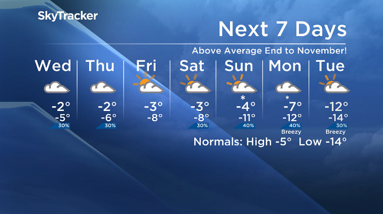
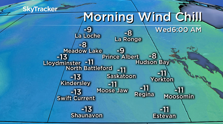
Temperatures have also been sitting around -2 throughout the entire overnight period, morning and into the afternoon with the mercury not expected to fluctuate too much through the rest of the day with wind chill values continuing to sit around -9.
Tonight
There remains a slight chance of flurries under cloudy skies tonight as temperatures dip back to around -4 or -5 after winds ease off this evening.
Wednesday
When you wake up tomorrow morning, it’ll feel around -11 with wind chill before temperatures rise to around -2 during the day, making for once again another above seasonal day to round off the month of November, where impressively nearly every single day was above normal!
Cloudy skies will also stick around from morning through afternoon with a slight chance of flurries earlier in the day.
Thursday-Friday
As the system bringing the snow to the southeast pulls off to the east, we see the chance of snow diminish heading into the remainder of the week.
Cloudy skies will stick around on Thursday with mostly cloudy skies again on Friday before some late day clearing may bring in a few sunny breaks before sunset.
December kicks off with temperatures staying fairly consistent as daytime highs hover just a few degrees below freezing and morning lows sit in mid-minus single digits.
Weekend Outlook
A weaker system will develop as it passes over the province on Saturday, bringing in a chance of flurries and keeping us under predominantly cloudy skies through the weekend.
Saturday will see a daytime high once again a few degrees below freezing, but a shot of arctic air will push in behind this system, cooling us off substantially on Sunday and into early next week with minus double digit temperatures in the forecast!
Nov. 29: This Your Saskatchewan photo was taken in Prince Albert by Melanie Marie:

Saskatoon weather outlook is your one stop shop for all things weather for Saskatoon, central and northern Saskatchewan with a comprehensive look at your local forecast that you can only find here.
Comments
Want to discuss? Please read our Commenting Policy first.