

A snowfall warning has been issued for Saskatoon, Prince Albert, Outlook, Watrous, Melfort, Cypress Hills, Swift Current and Leader areas for 10 to 15 centimetres of snow expected Tuesday night into Wednesday.

Environment Canada says another 10 to 20 millimetres of rain is expected Tuesday afternoon into the evening.
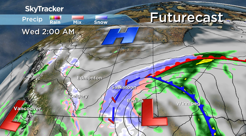
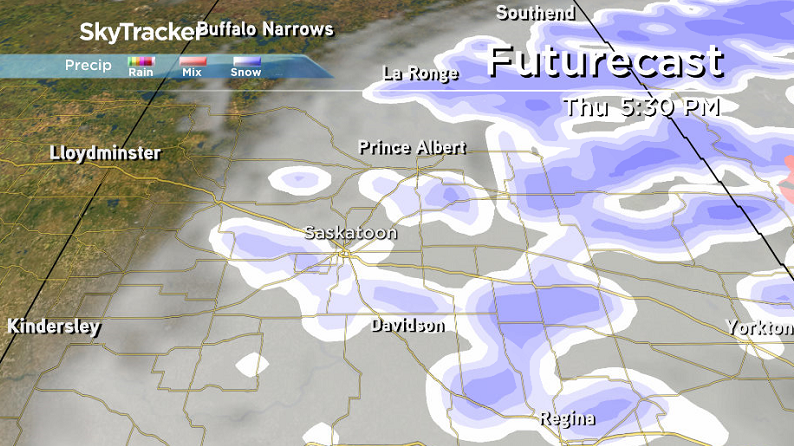
A special weather statement has been issued for much of central and southern Saskatchewan for snow, rain and wind through midweek with wintry weather into Wednesday.
As of 11 a.m. the snow has already begun falling in areas east and south of Saskatoon including Humboldt and the Cypress Hills.
The culprit is a major low pressure system that has spread an area of rain into southern Saskatchewan.
READ MORE: Blast of snow to hit Saskatoon, central Sask. Tuesday into Wednesday
The rain has moved out of the southeastern portions and as of Tuesday morning stretched from the Yorkton and Hudson Bay area through the northern grain belt to southwestern Saskatchewan and the Cypress Hills.
As a result east-central areas along the Manitoba border north of the Trans-Canada Highway are now under a rainfall warning with a further 25 to 50 mm expected on Tuesday and into Tuesday night.
As this slow moving system gradually pulls away Tuesday night the precipitation will slowly weaken.
A further 20 to 40 mm is expected in many parts of central and southwestern Saskatchewan today.
Precipitation and strong northerly winds will persist over much of the area Tuesday night and early Wednesday.
Most areas will see anywhere from 40 to 80 mm total by the time the system pulls out of the province.
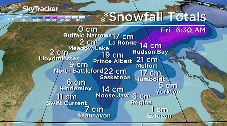
A snowfall warning has been issued for the Cumberland House and Pelican Narrows areas for a long period of snowfall with total amounts of 10 to 20 centimetres expected.
Heavy snow and strong winds will develop over the Pelican Narrows region Tuesday afternoon.
For the latest weather alerts download the Global News Skytracker weather app for iPhone, iPad or Android.
Saskatoon Forecast
Today
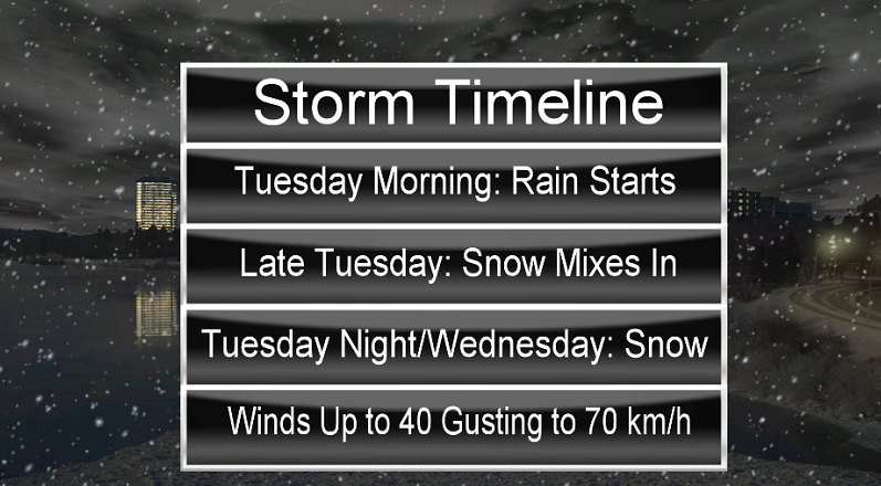
Rain started in Saskatoon this morning under cloudy skies with strong northeasterly winds at sustained speeds of 30 to 40 km/h with gusts into the 50 km/h range dropping temperatures from around 8 degrees earlier to 3 by the noon hour!
Snow has been reported east of the city in the Humboldt, Melfort and Nipawin areas.
As the airmass continues to cool through the remainder of the day, the rain in Saskatoon will switch to a rain/snow mix and then to snow this evening as temperatures slide down toward freezing and winds stay strong.
Tonight
The first few centimetres of snow will melt on contact with the ground tonight, but as heavier bands move through overnight and the ground begins to cool, we’re expecting the snow to start to accumulate, particularly on grassy surfaces.
Temperatures may slide a degree below freezing tonight, helping to enhance cooling as winds continue to gust upwards of 55 km/h.


Wednesday
After a night of snow, we’ll likely be waking up to a winter wonderland on Wednesday.
As the precipitation-packed low pressure system slides into central, snow will linger through the day with upwards of another 5 to 10 centimetres possible.
Saskatoon’s daily snowfall record for October 5 (Wednesday) is from exactly 100 years ago, back in 1916, and could be shattered if the record of 5.6 centimetres is exceeded through the day.
Northerly winds around 30 gusting to 50 km/h through the day will keep the mercury around the freezing mark with even cooler temperatures aloft keeping the precipitation type as snow.
Thursday-Friday
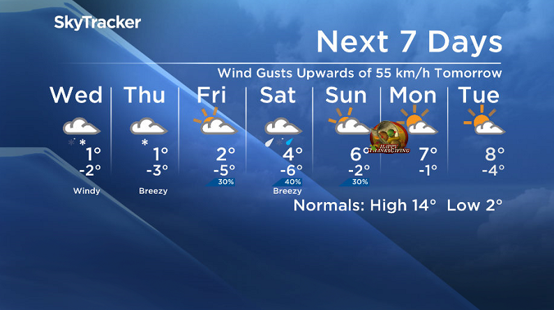
The snow should start to ease off on Thursday as the system pulls further east, which will also allow winds to drop back.
It’ll be a cooler day though once again with a daytime high struggling to get above the freezing mark once again.
Friday will start off chilly with a morning low expected to be a few degrees below freezing.
There’s just a slight chance of flurries through the day under partly cloudy skies with an afternoon high likely to be just above the freezing mark by up to a few degrees.
Thanksgiving Long Weekend Outlook
The Thanksgiving long weekend forecast is a bit up in the air still with little model agreement at this point.
A few disturbances are likely to pop by this weekend bringing in a chance of precipitation (of some sort, yet to be determined) on Saturday under cloudy skies before a partly to mostly cloudy Sunday with just a slight chance of precipitation before some sunshine should return for Thanksgiving Monday.
After starting off in mid-single digits on Saturday, daytime highs could be as warm as double digits by the end of the weekend, however there is still a lot of uncertainty with the long weekend forecast, so we’ll continue to keep an eye on the situation and bring you the latest as the date approaches.
Bonnie Evanochko took this Your Saskatchewan photo in Saskatoon:

Saskatoon weather outlook is your one stop shop for all things weather for Saskatoon, central and northern Saskatchewan with a comprehensive look at your local forecast that you can only find here.
Comments