

An early blast of winter with snow, strong wind and heavy rain is set to slam Saskatoon and central Saskatchewan on Tuesday and into Wednesday.

As a result, Environment Canada has issued a special weather statement for the city and much of central and southern Saskatchewan.
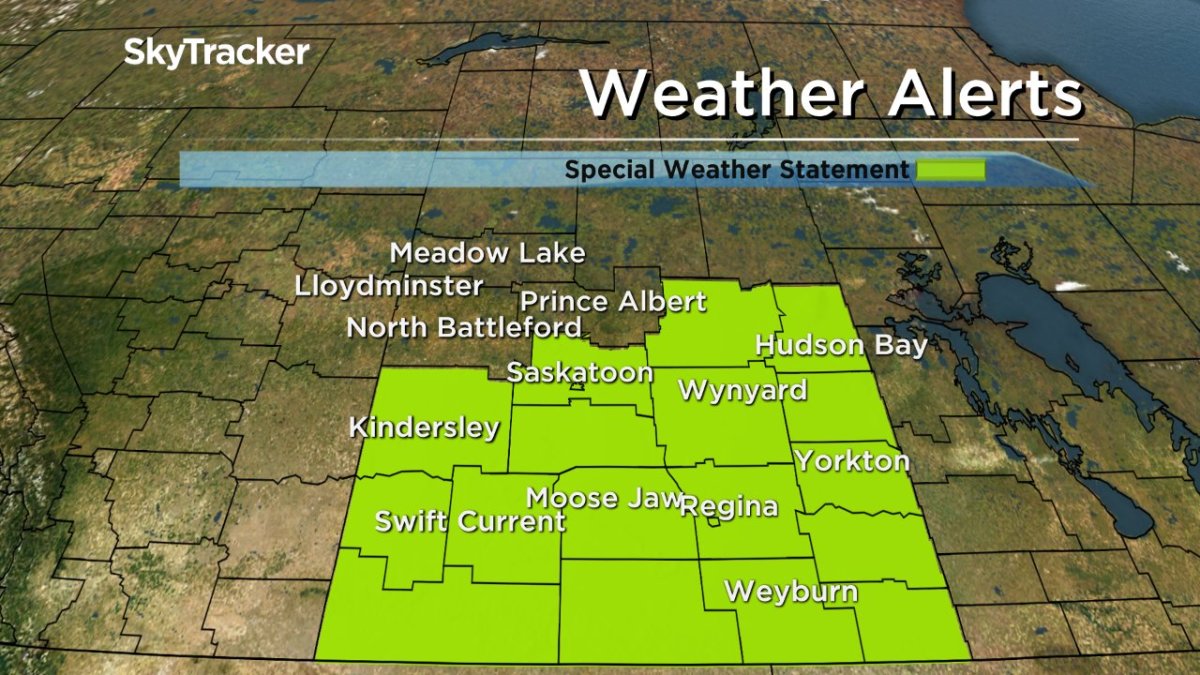
The agency says a swath of 25 to 75 millimetres of rain is expected with the system in some parts of the province.
Rain, heavy at times, is expected to reach Saskatoon early Tuesday morning and will fall heavily at times into the early afternoon, with 10 to 25 millimetres possible in the city.
Colder air will be continually cooling temperatures through the day, dropping them from the mid-single digits back close to the freezing mark into the early evening.
As that occurs, precipitation is expected to transition first to a rain/snow mix and then over fully to wet snow by evening.
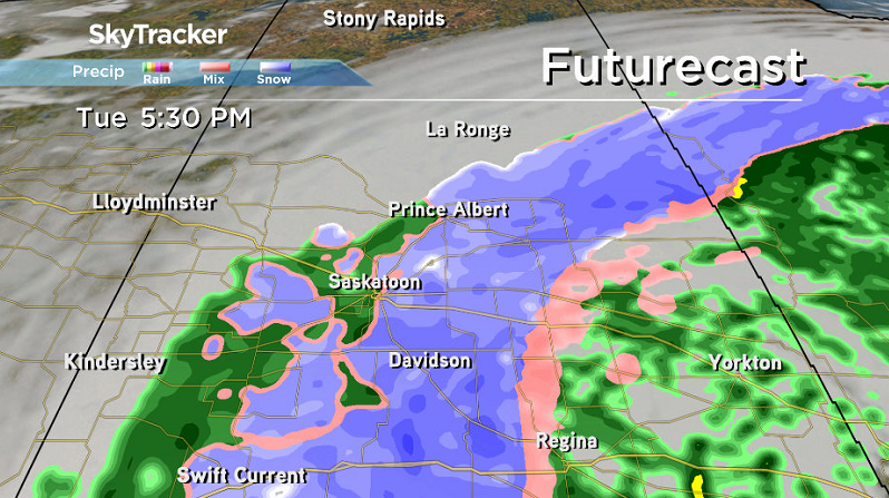
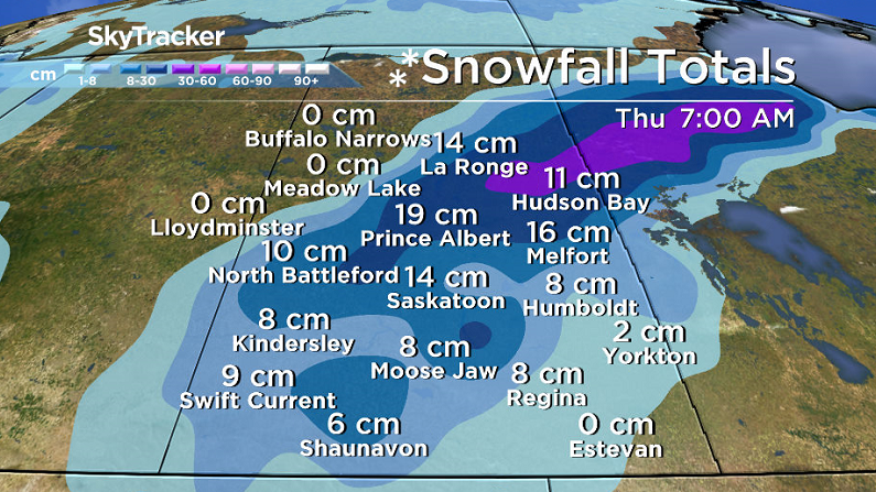
That snow is expected to continue falling through the night into Wednesday morning with most weather models in general agreement that upwards 10 to 15 centimetres could fall with the first few centimetres melting on contact with the ground.
Extremely windy conditions are also expected through the day Tuesday into early Wednesday with north-northeasterly sustained wind speeds up to 45 km/h and gusts upwards of 70 km/h at times.
The low pressure system responsible for the wild weather will move up from Montana and push into southeastern Saskatchewan.
I do think we’ll be waking up Wednesday with some snow on the ground as it continues to fall overnight into the day on Wednesday before tapering off on Thursday.
Saskatoon Forecast
Today
It was a cloudy start to the day in Saskatoon with temperatures sitting in mid-single digits.
As the snow-making system moves in, it’ll tighten up a pressure gradient over the city, bringing in northeasterly wind gusts up to 40 km/h later today as we hit a high potentially as warm as the low teens under mostly cloudy skies.
Tonight
Cloud cover will stick around tonight as the system builds in and winds pickup even further to around 30 gusting to 50 km/h and temperatures slip back into mid-single digits.
Tuesday
The day will begin with rain and temperatures in the mid-single digits along with north-northeasterly winds up to 45 km/h gusting upwards of 70 km/h at times through the day.
Rain will then transition to a rain/snow mix in the afternoon before switching to just snow into the evening hours through the overnight period as temperatures cool down toward the freezing mark.


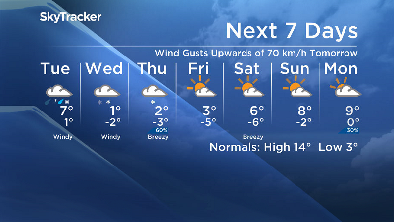
Wednesday-Friday
After a night of snow, we’ll be waking up to a winter wonderland on Wednesday.
As the precipitation-packed low pressure system slides from southeastern Saskatchewan into central Manitoba on Wednesday, lingering snow is expected to sit over the city with upwards of another 4 to 6 centimetres possibly falling during the day with a daytime high struggling to get above the freezing mark.

Saskatoon’s daily snowfall record for October 5 (Wednesday) is from exactly 100 years ago, back in 1916, and could be shattered if the record of 5.6 centimetres is exceeded through the day.
Winds will continue to be quite brisk from the north through the day at sustained speeds around 30 km/h with gusts upwards of 50 km/h at times.
The snow looks to taper off on Thursday as the system pulls further off into Ontario and winds ease back a bit to around 20 km/h from the northeast, but temperatures will struggle to climb up very far above freezing.
Then on Friday, we’ll then might start to see some sunshine as a weak high pressure system passes by north of the city.
That could give us a chilly start with the mercury slipping back into mid-minus single digits in the morning before recovering up a few degrees above freezing in the afternoon.
Weekend Outlook
This weekend looks to be a bit calmer with partly to mostly cloudy skies and just the slightest chance of precipitation with daytime highs pushing into mid-to-high single digits and overnight lows remaining below freezing.
This Your Saskatchewan photo was taken by Gloria Allison near Watson:

Saskatoon weather outlook is your one stop shop for all things weather for Saskatoon, central and northern Saskatchewan with a comprehensive look at your local forecast that you can only find here.
Comments