

After an entire year of warmer than normal monthly average temperatures, we’ve just pulled out of our first below normal month in Saskatoon!

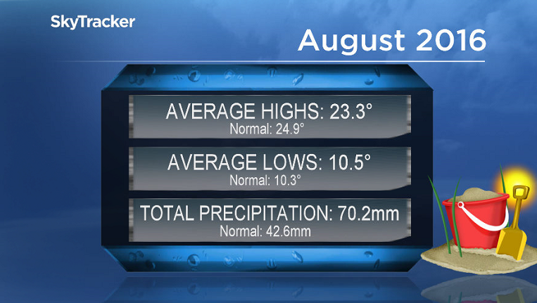
August 2016
Every single month since August 2015, Saskatoon’s average monthly temperatures have trended above normal – that is until August 2016.
Daytime highs were a total of 1.6 degrees cooler than normal, meantime overnight lows actually sat 0.2 degrees warmer than average.
But overall throughout the month, average temperatures trended just over half a degree below seasonal.
In terms of precipitation, it was a much wetter than normal month with over one-and-a-half times our average precipitation throughout the month.
Saskatoon saw 70.2 millimetres of rain throughout August when the city’s average is 42.6 millimetres – so we saw 165 per cent of our normal precipitation throughout the month.
Summer 2016 Recap
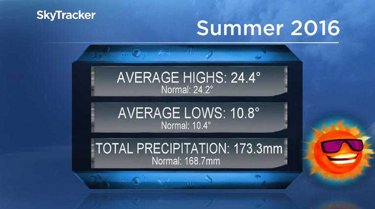
Looking back at the numbers for meteorological summer, which includes the months of June, July and August, Saskatoon saw temperatures slightly warmer than normal and near normal precipitation.
Overall both daytime highs and overnight lows were above seasonal with average temperatures trending 0.36 degrees warmer than normal.
In terms of precipitation, we saw 173.3 millimetres of rain fall through the three month period, when our average is 168.7 millimetres, making that approximately 103 per cent of our normal precipitation.
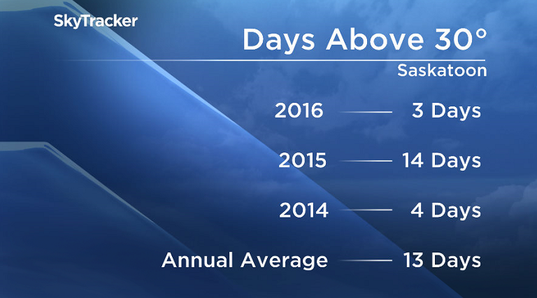
Normally Saskatoon sees 13 days above 30 degrees each year, however this year we’ve only seen three.

Get daily National news
Two of those days where the mercury spiked above the 30 degree mark were in May, the other one in early June and we haven’t seen one since.
Severe Thunderstorm Watch

Environment Canada has issued a severe thunderstorm watch for the La Loche, Buffalo Narrows and Île-à-la-Crosse areas for conditions favourable for the development of severe thunderstorms that may be capable of producing strong wind gusts, large hail and heavy rain.
Thunderstorms over parts of northern Alberta have the potential to produce severe weather through this evening.
These storms are expected to spread into northern Saskatchewan Thursday afternoon.
Saskatoon Forecast
Today
It’s been a pretty mild first day of school and start to September!
There were a few showers to start the day in Saskatoon as temperatures dipped back to a mild 16 degrees under mostly cloudy skies.
As rain began moving out of the area, the mercury started shooting up into the low 20s by noon, expecting to top out in the high 20s this afternoon with a slight chance of a late day shower or a stray thunderstorm.


By noon areas southwest of the city were already up into the 30s!
Tonight
We’ll see some clouds clear out tonight as temperatures slide back into the low teens.
Friday
The final day of the work week looks like it’ll still be quite warm ahead of a cold front that’ll kick through late in the day.
Clouds will roll back in early in the morning with a good chance of rain or thunderstorms from mid-morning into the afternoon as a developing area of low pressure swings over the area.
Depending on the timing of the rain, temperatures should top out around 26 or 27 degrees with winds picking up in the evening as the cold front moves in.
Long Weekend
Despite the sunshine that’ll be out on Saturday, it’ll be cool and windy after a cold front moved through overnight as cool air continues ushering in.
Winds will be at sustained speeds into the 30 to 40 km/h range with gusts upwards of 50 to 60 km/h as temperatures struggle their way into the upper teens.
Sunday looks calmer, but still a bit breezy as clouds build back in during the day and our daytime high gets pushed down even further into the mid-teens.
Labour Day Monday looks like it’ll be the coolest of all the days with a morning low in mid-single digits and afternoon high around 15 degrees under mostly cloudy skies.
Work Week Outlook
Afternoon highs do recover out of the mid-teens into the upper teens through the start of the short work week, possibly pushing as high as the low 20s by the end of the week under partly to mostly cloudy skies with a chance of showers at times.
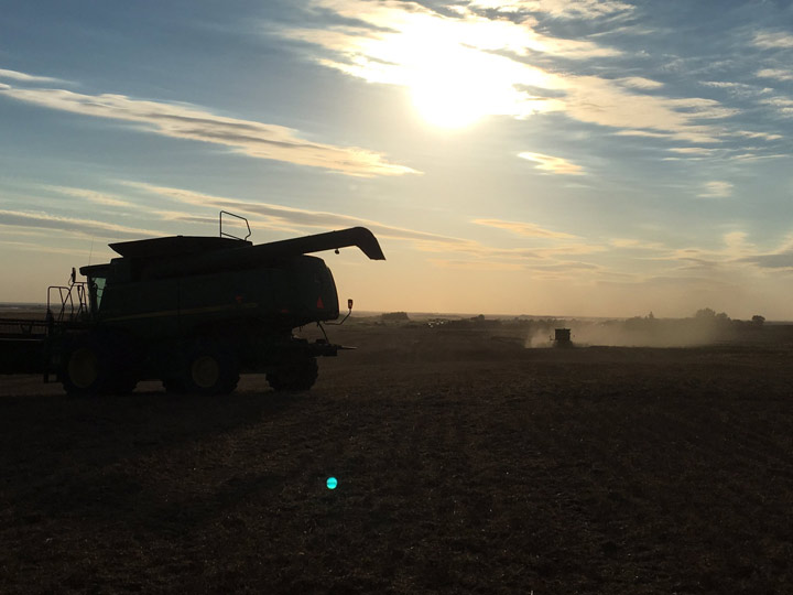
This Your Saskatchewan photo of harvest in full swing was taken by Phil Heilman in the Wilkie area:
Saskatoon weather outlook is your one stop shop for all things weather for Saskatoon, central and northern Saskatchewan with a comprehensive, detailed look at your local forecast that you can only find here.
Comments
Want to discuss? Please read our Commenting Policy first.