
Weather update: Wednesday December 17th 5am

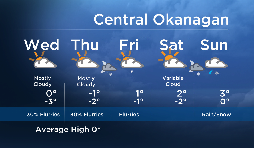
Today will be similar to yesterday. The risk of a few snowflakes continues under a weak southwesterly flow aloft, but little accumulation is expected, if any.
Tomorrow will also be comparable, but the risk of flurries will increase Thursday night and Friday as a stronger disturbances moves inland Friday.

Get daily National news
Get daily Canada news delivered to your inbox so you'll never miss the day's top stories.
By providing your email address, you have read and agree to Global News' Terms and Conditions and Privacy Policy.
On Saturday, we will be in between systems and sunny breaks are possible, but another moderate weather system will move in on Sunday. However Sunday’s system will also bring milder air and raise freezing levels. This means we will likely see a mix of rain and snow for the second half of the weekend.
- Gatineau homes at risk from rising waters as Ontario, Quebec face flooding concerns
- State of emergency declared in Peguis, Fisher River ahead of potential flooding
- Special weather statements issued for parts of Ontario, Quebec
- Most homes at risk of flooding on Manitoba First Nation still need protection: Kinew


See you at 5, 6:30 and 11pm tonight!
Today’s Highs: -4 to +2C
~Wesla/Duane
Comments
Want to discuss? Please read our Commenting Policy first.